
Tale of Three Calgary Pedestrian Bridges
Calgary is blessed with almost 1,000 km of pathways (one of the world’s largest urban pathways) used by pedestrians, runners and cyclists year-round. One of the key elements of the pathways system is its pedestrian bridges which range from “plain jane” functional bridges to multi-million dollar iconic bridges designed by world renowned architects and engineers. Some have been created with much controversy, while others have flown under the radar.
This is the story of three recently completed pedestrian bridges that I have been following for several years – Bow Trail, Peace and St. Patrick’s Island bridges.
Calgary’s “Other Red Bridge”
While the Peace Bridge and St. Patrick’s Island bridges got all the media attention, the new pedestrian bridge over Bow Trail at the western entrance into the downtown just quietly got built. As a minor element in the massive billion-dollar West LRT project, there was no international design completion, nor any elaborate public engagement process. The design was given to two local engineers - Edmund Ho and Monty Knaus of Calgary’s MMM GROUP.
In their 2014 Transportation Association of Canada (Structures Session) Conference presentation, the bridge is described as a “rotated-ellipse arch,” but most people just see it as a representation or interpretation of Calgary’s iconic Chinook Arch. In my mind, there couldn’t be a more appropriate design for one of the downtown’s key gateways, seen by 100,000+ Calgarians and visitors who pass under it, cross over it or by it (Crowchild Trail) every day.
Its Canada Flag red colour helps make it stand out against the dramatic Calgary sky that can range anywhere from pure white to deep blue. Usually I am the guy asking for more ornamentation, but in this case, the simplicity of the design works well. Who says engineers have no sense of urban design? It also offers one of the best views of Calgary’s stunning downtown vista, which becomes visible at exactly this point when travelling east.
This bridge is an important connection in Calgary’s pathway system as it provides a connection to the Bow River pathway for all of the communities west of Crowchild Trail and south of Bow Trail, for both leisure and commuter use. It also provides access to a bus stop on Bow Trail.
The bridge spans all six lanes of traffic as well as the LRT track, with a span length of 50 metres from end-to-end of the half ellipse and another 12 metres of deck supported by steel props on the south end of the bridge. Narrowest of the three bridges at only 3 metres wide; this means it has no room for segregated bike and pedestrian traffic. It also has no lighting on the bridge itself; though there are street lamps that lights up both the bridge for nighttime use. Note: The City was unable to give me the cost of this bridge as it was buried in the cost of the West LRT project, but in chatting with engineers the thought is the cost would be in the $6M range (this is the smallest of the three bridges).
The Bow Trail Bridge opened in December 2011, if you haven’t visited it, you should check it out for its spectacular view.
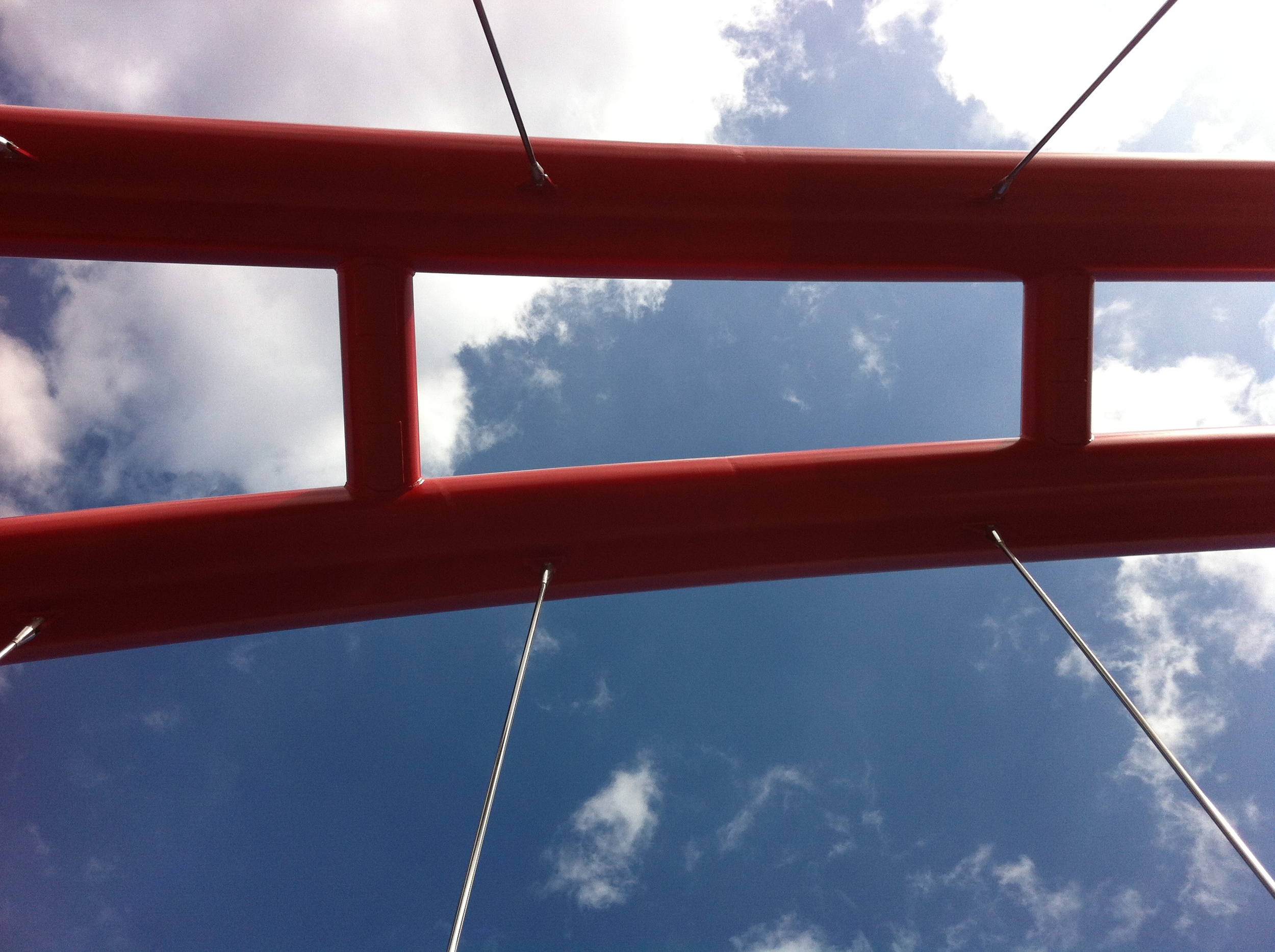
The sky view from the Bow Trail bridge.

Currently the bridge connects an old seniors cottage village and park, as well as being a key link in Calgary's nearly 1,000 km pathway system. Plans are currently being developed to transform the seniors site into a more mixed-use urban village with seniors as the focus.
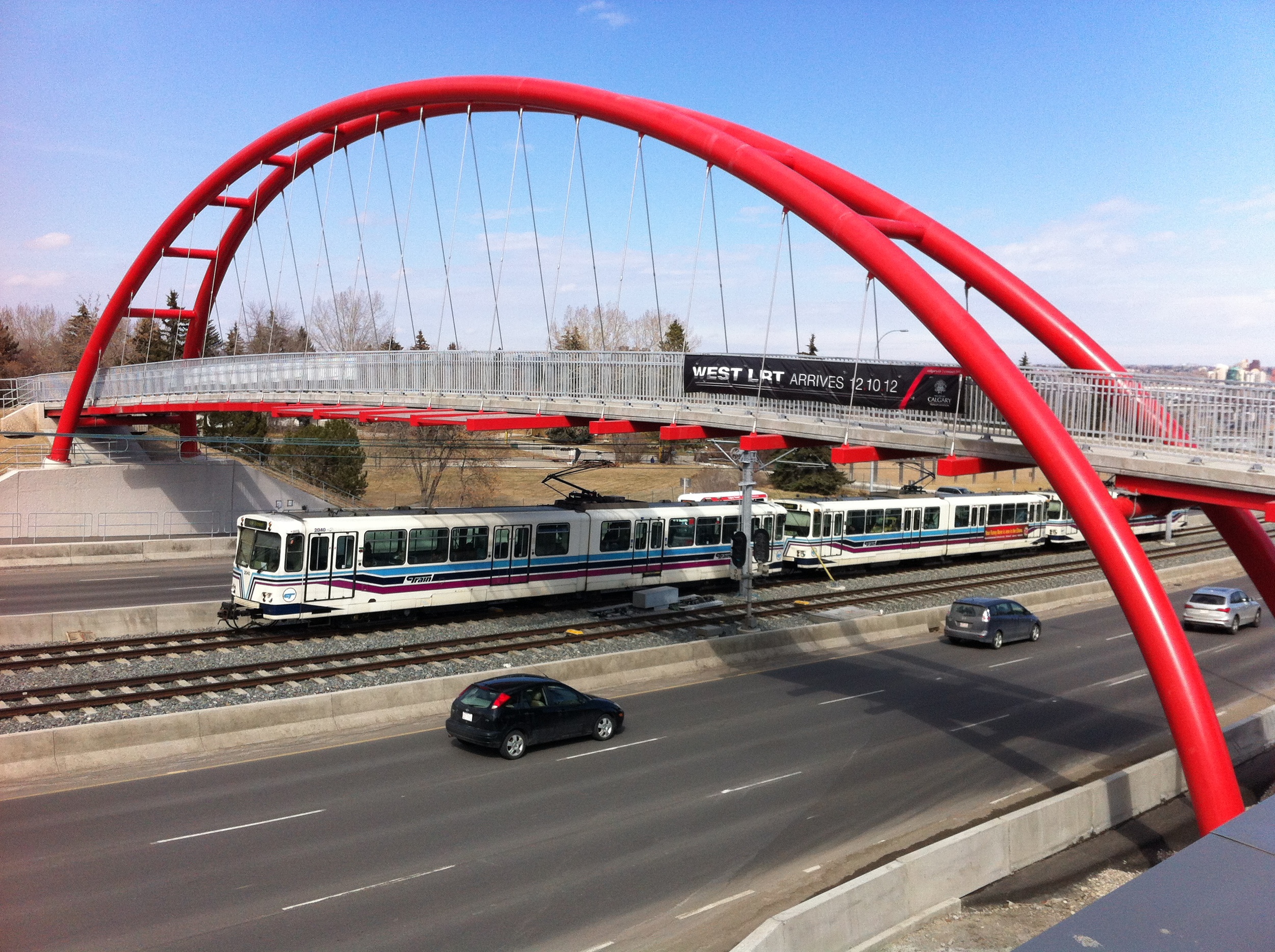
The bridge spans the river of buses, trains and automobiles entering and exiting the Downtown along Bow Trail.

A Chinook Arch which was the inspiration for the Bow Trail bridge.

The city vista from the Bow Trail bridge is stunning.
Peace Bridge
The Calatrava (the world famous Spanish architect Santiago Calatrava was the designer) Bridge, which later became the Peace Bridge had very strict requirements because of the environmental sensitivity of the Bow River (one of the great fly fishing rivers in the world), no piers in the water (in an effort to minimize the ecological footprint) and restricted height (due to the nearby heliport). The bridge also had to meet the following specifications:
- Withstand Calgary's one-in-100 year flood cycle (who knew this would happen only one year after its completion)
- Minimum 75-year life span
- Barrier free access for people of all mobility types
- Sufficient light so public felt comfortable and secure at all times
Calatrava’s Peace Bridge is unique in that it is doesn't incorporate his signature asymmetric monochromatic white forms with anchored high masts and cables.
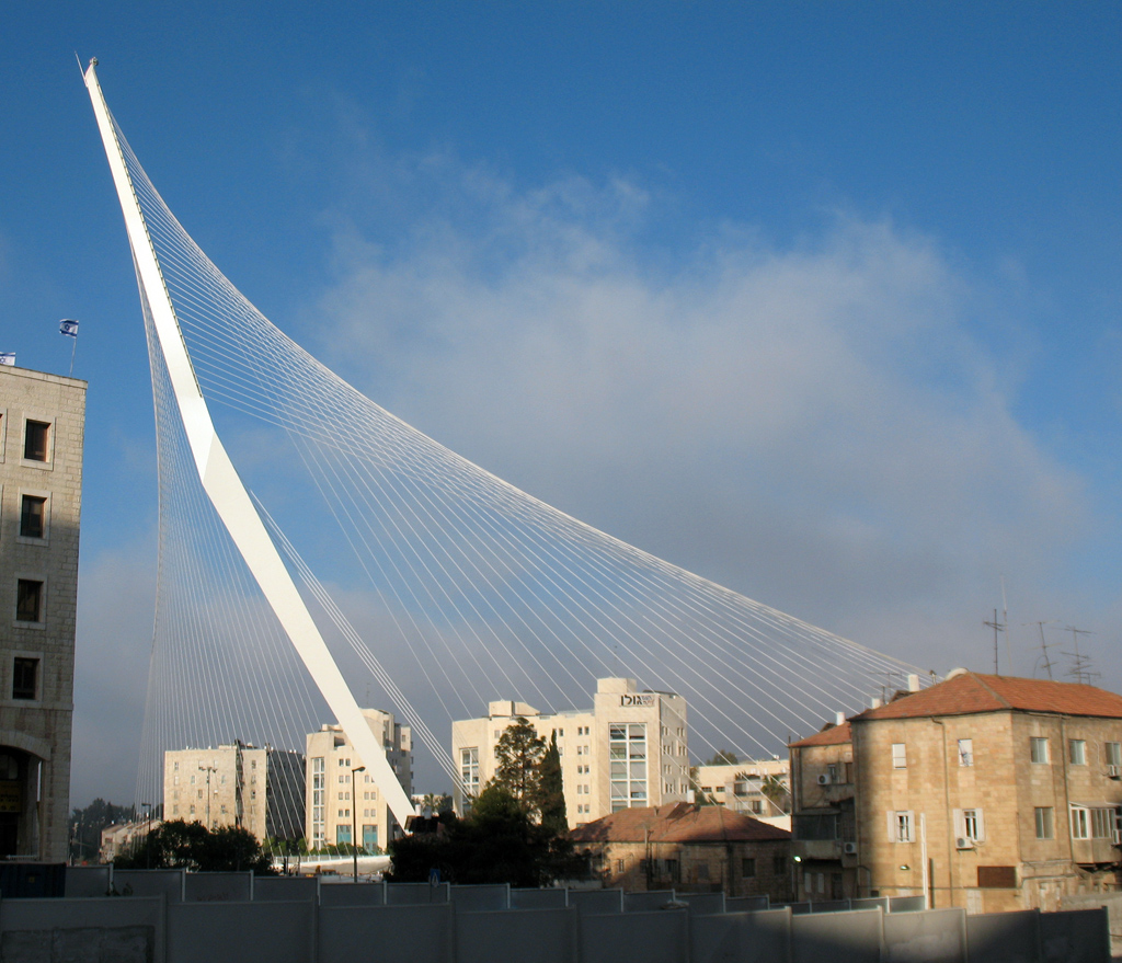
Calatrava's Chords Bridge for pedestrians and trains in Jerusalem.
The candy cane red Peace Bridge name references the fact the bridge’s north side is on Memorial Drive, a boulevard that pays homage to Canada’s war and peacekeeping efforts over the past 100+ years. At the same time as the bridge was being built, Memorial Drive received a major makeover, creating a much more ceremonial street complete with the new Poppy Plaza, public art and ornamental lighting and decorative boulevard.
The bridge was steeped in controversy from day one for several reasons. The cost ($20M+ was deemed too high by many for a pedestrian/cycling bridge). Why was it sole sourced? Why no pubic engagement? Was it even needed?
And then there were the delays. An independent inspection company was engaged to inspect all of the welds completed in Spain. Red flags were raised about the aesthetics and safety of the welds, which resulted in all the welds being ground down and redone on site. The bridge sat on the riverbank for months - covered in orange tarps like some Christo artwork - while welders redid all of the welds.
Funding for the Peace Bridge was provided through the City of Calgary’s Transportation Infrastructure Investment Program (TIIP), which defines the priority and timing of major infrastructure construction projects. One of the key elements of this program is to foster more pedestrian and cycling opportunities in high-density areas where these modes are more efficient at moving people, supporting land use and lessening environmental impacts.
The final costs were $19.8M for construction, $3.45M for architectural and structural design and specialized and $1.25M in administration, quality assurance and insurance for a total of #24.5M.
The Peace Bridge is 126 meters long and 6 meters wide, making it twice as wide as a normal pedestrian bridge, allowing separate pedestrian and cycling lanes (not that you would know it as pedestrians walk wherever they want). It is well lit to promote nighttime use. The bridge originally to be opened in fall of 2010 didn’t open until March 2012.
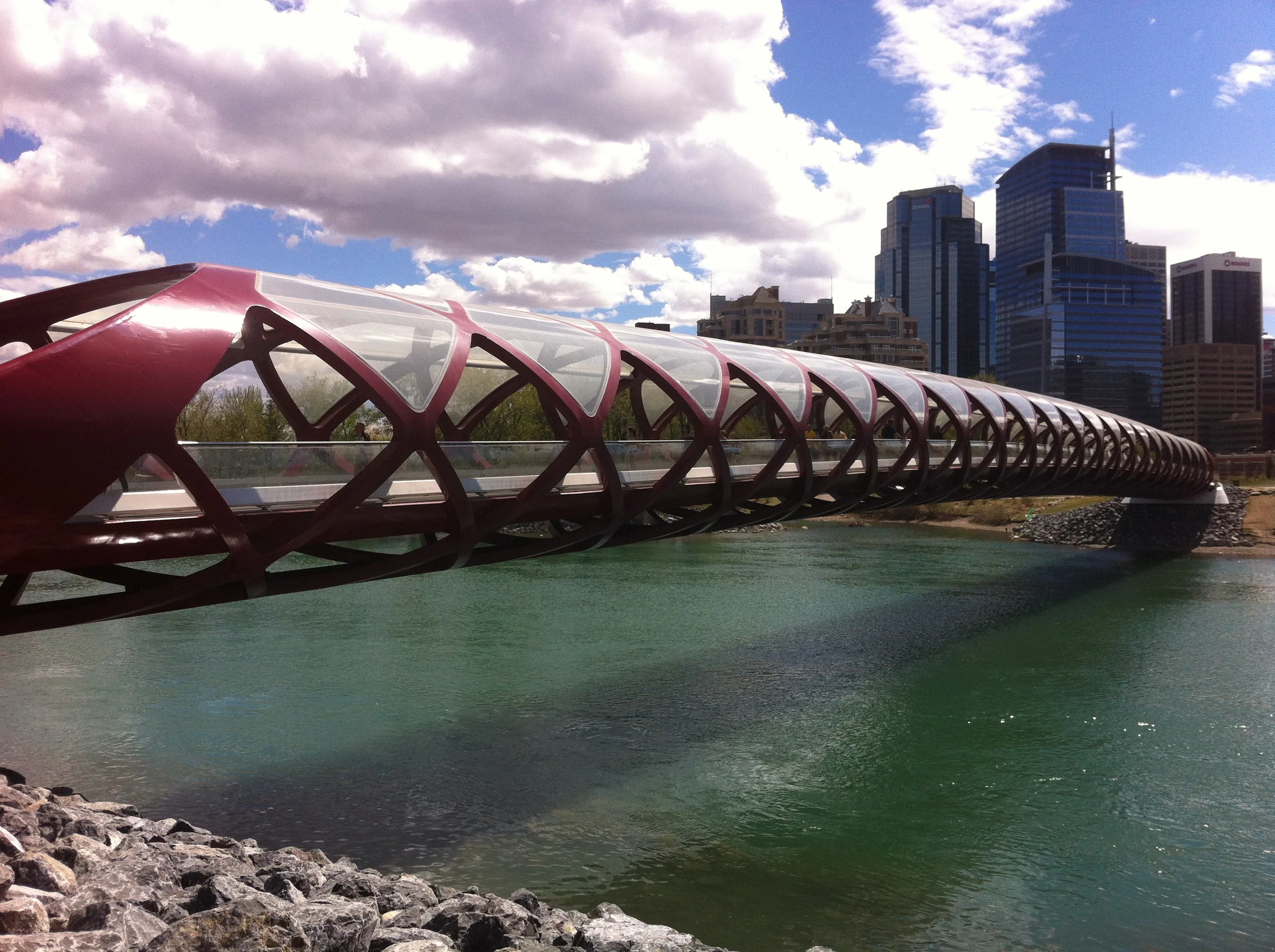
Peace Bridge looking south into downtown over the glacier waters (green) of the Bow River. To me the bridge dominates the river, creating a bold "look at me" statement that takes away from the natural beauty of the setting and blocks rather than enhances the view of the city skyline and Prince's Island.
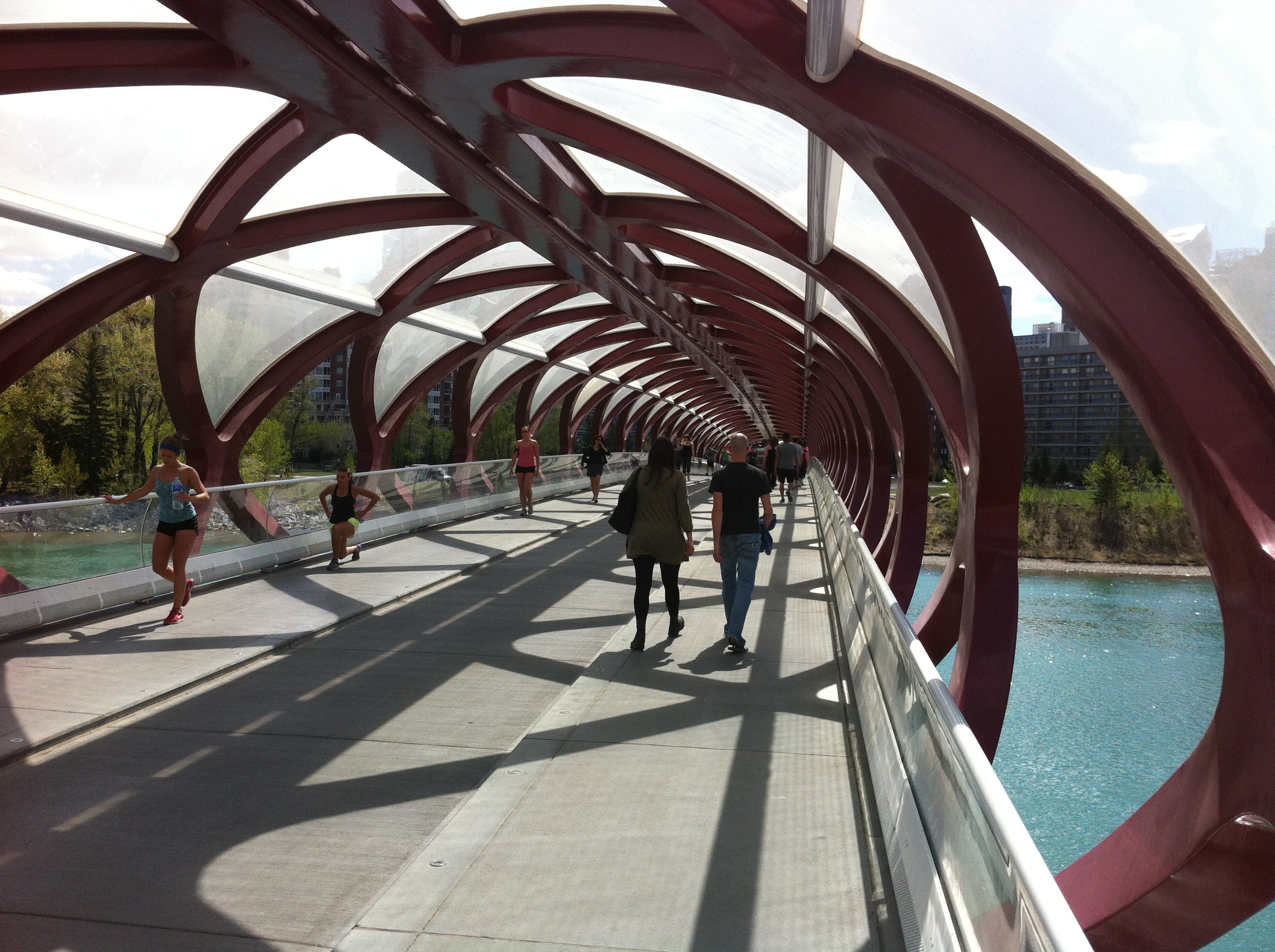
The Peace Bridge is a popular place for a noon hour stroll or workout - it is an outdoor gym. The skeleton-like structure creates interesting viewing vistas for those who stop, while at the same time blocking an expansive view of the river, the sky, park and skyline as you proceed along the bridge. Visually it seems antagonistic, rather than synergistic with the natural setting.

Peace Bridge links the north and south side of the extensive Bow River pathways system for walkers, joggers and cyclists. It is like an impromptu parade at noon hour in the summer, which creates a wonderful urban vitality.
St. Patrick's Island Bridge
While the cost of the St. Patrick’s Island Bridge was similar to the Peace Bridge, everything else about this bridge’s design and construction were different. There was an international design competition attracting 33 local, national and international concepts. All designs were shared with the public - over 2,000 Calgarians participated in the engagement process. Kudos to Calgary Municipal Land Corporation (CMLC) for managing what has become the public engagement model for major public projects in Calgary.
Eventually, the design of two engineering firms - RFR from Paris and Halsall Associates from Calgary – was chosen. Their design was nicknamed the “skipping stone” bridge as its three arches reminded people of a child playing at the edge of the river skipping a stone off water - a fitting image for the urban playground image being fostered by CMLC for East Village, Riverwalk and St. Patrick’s Island.
In September 2012, construction crews began work, putting in place temporary berms, extending into the Bow River from the north and south banks, to support the base and bridge deck structure. The steel arches were manufactured by ADF Group Inc. in Montreal. The arch sections vary in size (32 to 99-metres long) and weight (70,000 kg to 200,000 kg), were then shipped by truck to Calgary where they were welded together on site and eventually lifted in place with a 250-tonne capacity crane.
The bridge connects East Village to the charming Bridgeland neighbourhood, as well as provides a new attractive cycling commuter path to downtown from the northeast quadrant of the city. It is also a key element of the mega-makeover currently underway on St. Patrick’s Island, which is currently being to transform it into a year-round meeting and activity place. It replaces an existing bridge near the west end of St. Patrick’s Island, which did not offer a direct connection to the north bank of the Bow River (all of the materials from the old bridge have been recycled in various ways).
Like the Peace Bridge, St. Patrick’s Bridge has been designed with sufficient width for pedestrians and cyclists, but it doesn't have segregated lanes. It does have purpose-built lighting on the sidewalk of the bridge, but not lighting on the arches which would have been beautiful against the dark river especially in the winter. The total length of the bridge is 182 metres with a maximum bridge width of 10.7 metres and minimum width of 7.3 metres, making it the longest and widest of the three bridges.
The St. Patrick’s Island Bridge opened in the fall of 2014 after a one-year delay due to the 2013 flood and with no controversy from beginning to end.
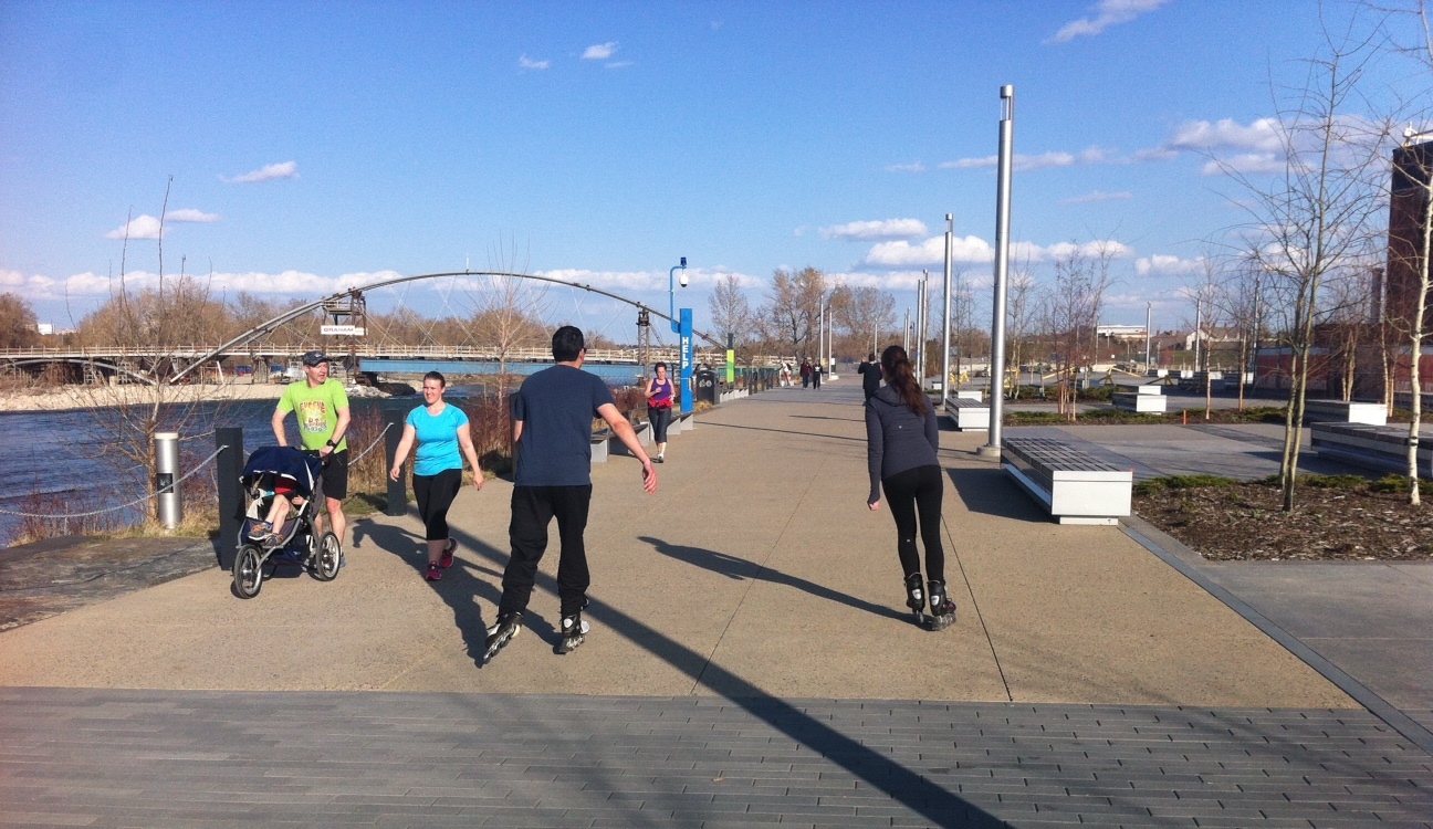
People of ages and backgrounds enjoy the East Village Riverwalk for various activities. The St. Patrick's Bridge is in the background under construction.

St. Patrick's Bridge has become a popular meeting place for walkers, joggers and cyclists. It has some similarities to the Bow Trail Bridge with its Chinook Arch shape and great views of the dramatic downtown skyline and the prairie sky. The bridge has an elegance that seems to frame the river, skyline and sky without being overbearing. (Photograph by Mark Eleven Photography, extended in courtesy of CMCL.)
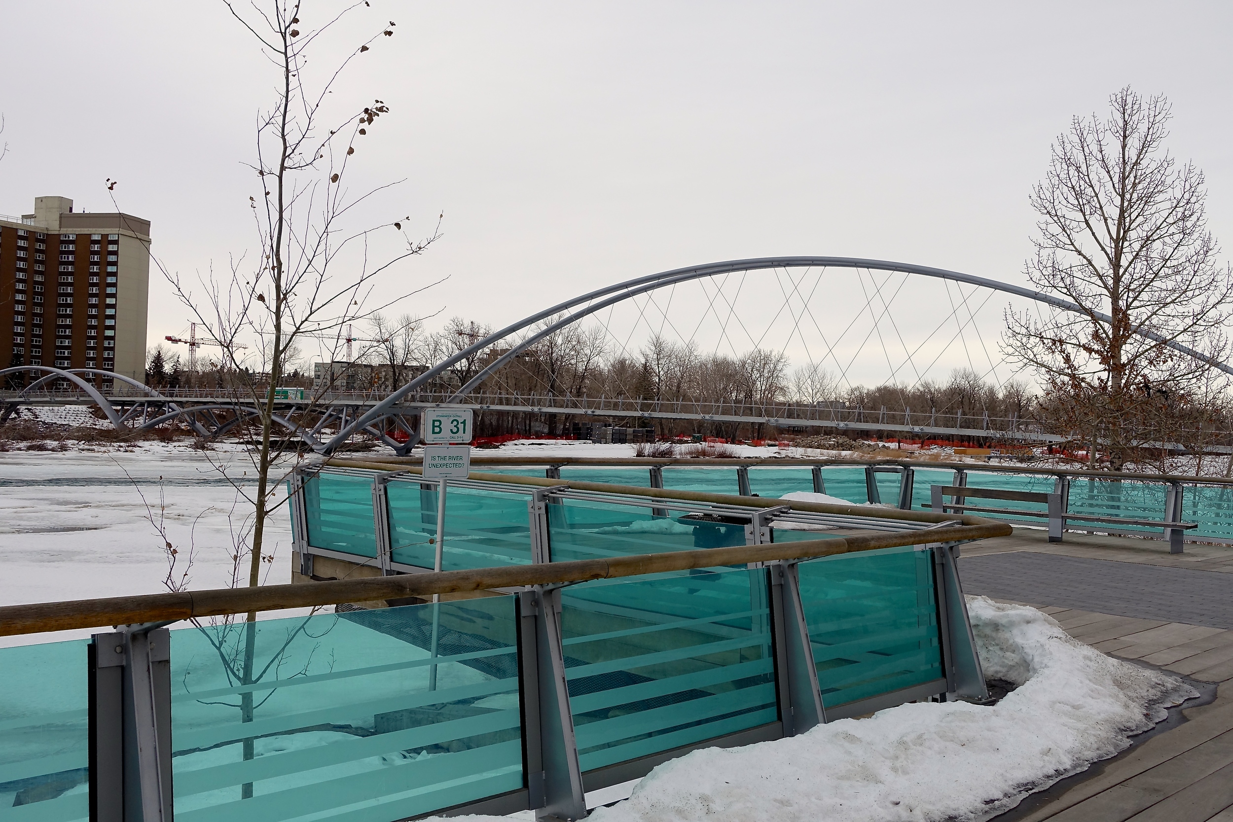
View of bridge from one of the Riverwalk platforms. You can see the three arches aka skipping stones, with one under the bridge. There is an elegance and fluidity in the design that works even in a winter sky.
Last Word
There are many lessons learned from the tale of these three bridges. First, engineers can design engaging urban structures. Second, it is critical to have local representation on any major Calgary design project, as they will bring a critical eye to reflecting Calgary’s unique sense of place. Third, there must be an effective public engagement process.
As well, a fourth lesson might be that it is not necessary to have an international design competition to ensure high quality urban design. Calgary has a strong, diverse, competent and experienced design community capable of creating great buildings, bridges and public spaces. I am convinced that if we really want to celebrate and express Calgary’s unique sense of place we will have to do it by engaging designers locally who understand and appreciate our urban culture and not import it form elsewhere.
My personally favourite of the three bridges is the Bow Trail Bridge for its Calgary red colour (think Stampeders, Flames and Calgary Tower), uncomplicated design and subtle reference to one of Calgary’s signature differentiators - the Chinook Arch.