
Calgary's SoBow Trail: One Of The Best River Banks In North America!
I bet you have never heard of Calgary’s SoBow Trail? That’s probably because it isn’t an official trail, but it should be. What is the SoBow Trail, you ask? It is the 12 km long south bank of the Bow River from Edworthy Park to Harvie Passage.
While some of the land acquisition started in middle of the 20th century, the transformation of the Bow River’s south bank into an urban gem has accelerated over the past 25, to become an amazing collection of 20+ parks, plazas, pathways and bridges.
In my estimation it has evolved into one of the best urban river banks in North America…maybe in the world. It is one of the reasons Caglary is the 5th best city to live in the world.
Don’t believe me? Read on…
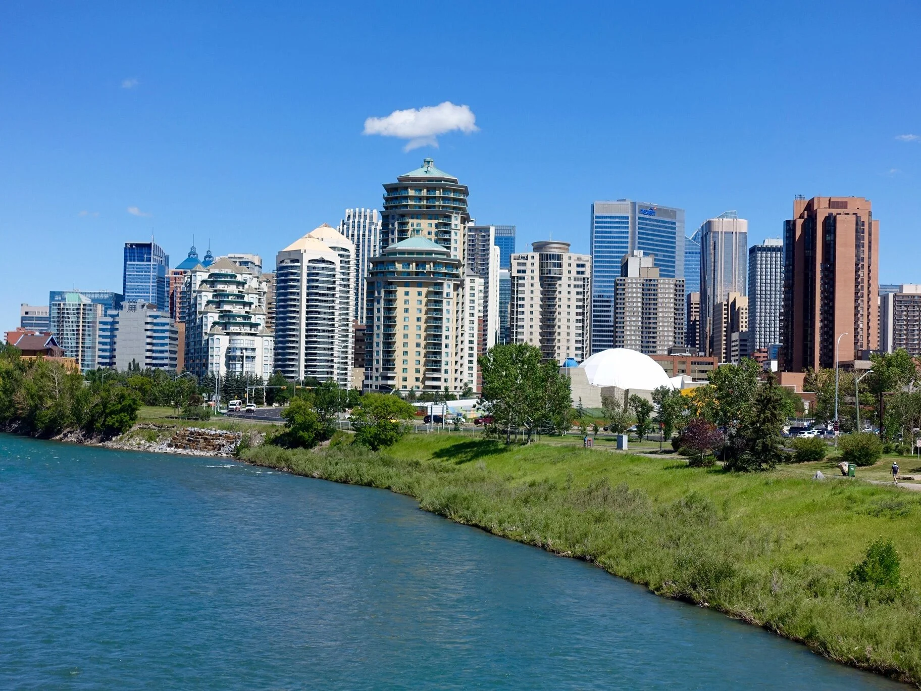
The Bow River’s south bank as it enters the downtown’s western edge.
No Master Plan
To my knowledge, there hasn’t been a master plan for this development. Rather, it’s been an organic evolution of several master plans - from Calgary Municipal Land Corporation’s River Walk and St. Patrick’s Island plans to the City of Calgary’s Prince’s Island master plan and West Eau Claire and Public Realm Plan.
It seems like every few years, a new public space has been added to the Bow River’s south bank.

Let’s Take A Walk Along The SoBow Trail

The 169 hectare Edworthy Park (which also includes the Douglas Fir Trail, the most easterly site that the Douglas Fir tree grow and historic Lawrey Gardens) at the western edge of Calgary’s city centre will be our starting point..
It has a popular natural pebble beach and is a popular family picnic spot with hundreds of firepits and BBQs.
The park, once part of the huge Cochrane Ranche, was purchased by Thomas Edworthy in 1883 for the Edworthy homestead that included not only the family farm but sandstone quarries and other agricultural activities. It was later purchased in 1962 by the City of Calgary for the development of a park at the edge of the city.
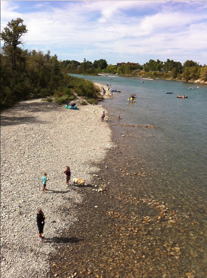
The natural pebble beach at Edworthy Park.

John Lawrey settled in the area Calgary in 1882 buying the land east of Edworthy’s where he created a market garden to provide fresh fruit and vegetables to the railway crews and other homesteaders. He died in 1904, but left the property to his nephews who continued to farm the land until the end of World War 1.
Today, it is a natural area with forest, meadows, ponds and a spectacular gravel bar that lets you walk out to the middle of the river.

The huge gravel bar in the Bow River is a popular spot for people to create rock formations like this one.

As you continue walking east and you will discover a hidden sculpture park and beach volleyball courts. You have arrived at Pumphouse Park whose name pays tribute to the , Bow River Pumphouse No. which was an integral part of the City’s water supply system form 1913 to 1933.

Keep going east and you will walk under the Crowchild Trail bridge where you will find the charming Dave Freeze pedestrian bridge.

Continue eastward, go under the 14th Street bridge and you arrive at Nat Christie Park, a narrow strip of land between the pathway and 4th Avenue SW, that has been converted into a sculpture park. Here sits about a dozen artworks carved by members of the Stone Sculptures Guild of North America using local 60,000 year old Paskapoo sandstone. The Park is a legacy of the Group’s symposium held on Prince’s Island in 1998.

And just across the street is Shaw Millennium Park, a popular festival site and home to one of the largest public skateparks in the world - at 75,000 square feet. Other amenities include basketball and beach volleyball courts.

Here too you will notice the dome of the old Centennial Planetarium (designed by Calgary architectural firm McMillan Long and Associates in 1967) which recently reopened as a contemporary art gallery with plans for a major expansion and renovation.

There is also the historic red bricked Mewata Armoury building built between 1915 and 1918. It is still home to local Militia Units, chiefly The King's Own Calgary Regiment (RCAC) and The Calgary Highlanders, but also 15 (Edmonton) Field Ambulance Detachment Calgary, the 41 Canadian Brigade Group Influence Activities Company (attached to The King's Own Calgary Regiment (RCAC)) and various cadet organizations.
But let’s keep going as there is lots more to see.

Soon, we you’ll arrive at the historic Louise Bridge built in 1921 and named after Louise Cushing, the daughter of William Henry Cushing, Calgary’s Mayor from 1900 to 1901 (yes, just one year). Under the bridge is The Wave, where the Bow River current creates a natural wave perfect for river surfing. The Alberta River Surfing Association is working with Calgary-based Surf Anywhere to develop the area a world class river surfing park.
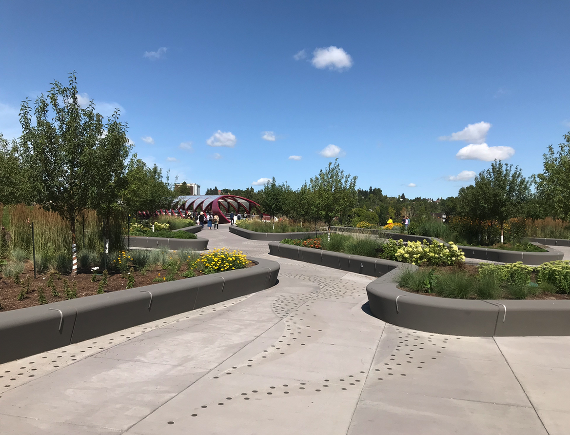
A bit further and you are at new West Eau Claire Park at the south entrance to the iconic Peace Bridge designed (the latter by world renowned bridge designer Santiago Calatrava).
The $10.6 million park (30% of the budget was used for flood mitigation) designed by Calgary’s O2 Planning + Design is meant to simulate a river delta with cyclist, runners, walkers and now e-scooters being the “water” flowing off the Peace River onto the Bow River pathway using different streams.
The park also contains a subtle public artwork was created by Calgary-based artists Caitlind R.C Brown and Wayne Garrett who installed 12,000 brass “survey monuments” i.e. loonie sized brass coins throughout the delta each have simple messages collected by asking Calgarians along the pathway “where they are going or where they want to be?”

You’ll also find here a new pebble beach with lovely lounge chairs to sit and watch the river flow by. It truly is a special place and a good example of how sophisticated Calgary’s urban design has become in the 21st century. The beach offers the perfect view of the Peace Bridge.

The promenade from the West Eau Claire Park to Eau Claire Plaza is popular with Calgarians of all ages and background. Recently mega long benches were added as part of the new flood mitigation design.

But time to move on – and only a few strides away from the formal entrance to Prince’s Island and Eau Claire Plaza. Prince’s Island Park is named after Peter Prince who, in 1886, built the Eau Claire Lumber Mill at this site. He dug a channel in the river to bring the logs from the Bow River to the mill. The channel is now the Prince’s Island lagoon and it was instrumental in converting what was once a migrating gravel bar to more permanent island, resulting in the creation of the park. The City purchased the land from the Prince family in 1947 for a park.
The Park hosts many festivals not the least of which is Calgary’s International Folk Festival. As well you’ll discover the Chevron Learning Pathway, a small sculpture park and one of Calgary’s oldest and best restaurants - River Café. Urban Epicentre

Prince’s Island lagoon is a popular place to sit especially when the Calgary Folk Festival is happening on the island.

Eau Claire Plaza, developed in the early 90s as park of Eau Claire Market is also home to numerous festivals and events including A Taste of Calgary food festival. It also has a popular wading pool and spray park for young families. It is the gateway into the downtown.

Just a few steps eastward and you encounter a large propeller-like artifact the middle of the pathway. Indeed it is a propeller from a nameless arctic ship. The plaque explains that the propeller which served many years in the Arctic was donated to the City of Calgary by the Society of Naval Architects and Marine Engineers (SNAME) in 1993 to commemorate the fact that Arctic section of SNAME, was started in Calgary in 1980 to support arctic oil and gas exploration.

Prince’s Island sculpture park.

Prince’s Island lagoon with Jaipur Bridge. The Jaipur Bridge which links the Eau Claire Plaza to Prince’s Island, was built in 1968 to honour Calgary’s sister city in India. Plans are currently being developed to replace the bridge in 2020 to accommodate the increased traffic.
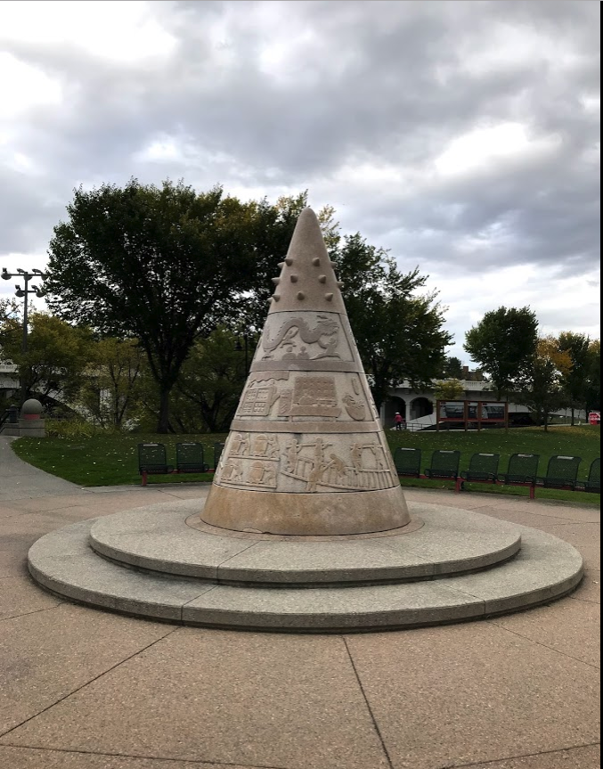
Next stop - Sien Lok Park on the northern edge of Chinatown. This park, created in 1982 is Chinatown’s only green space. The cone-shaped sculpture in the middle of it, titled “In Search of Gold Mountain,” was sculpted by Chu Honsun using 15 tonnes of granite from Hopei Province in China. The park has several other interesting artworks and two majestic Chinese Lions. The park is very popular with the Canadian Geese, so be careful where you walk or sit!

The iconic 1916 Centre Street Bridge with its lions modelled after the bronze lions at Trafalgar Square, London, and then to the popular Jack & Jean Leslie RiverWalk, which winds its way along the Bow River’s edge to where it meets the Elbow River.

As you pass under the Centre Street bridge don’t miss the decorative Chinatown fence.

As you stroll along the RiverWalk, you will also pass by the 1910 Reconciliation Bridge, originally named the Langevin Bridge after Hector-Louis Langevin, a founder of Canada’s confederation and one of the architects of the nefarious residential schools. It was decided in 2017, as part of Canada’s attempt to reconcile the injustices done to First Nation peoples to rename the bridge. The bridge is beautiful in the evening when it is lit up.
East Village Renaissance
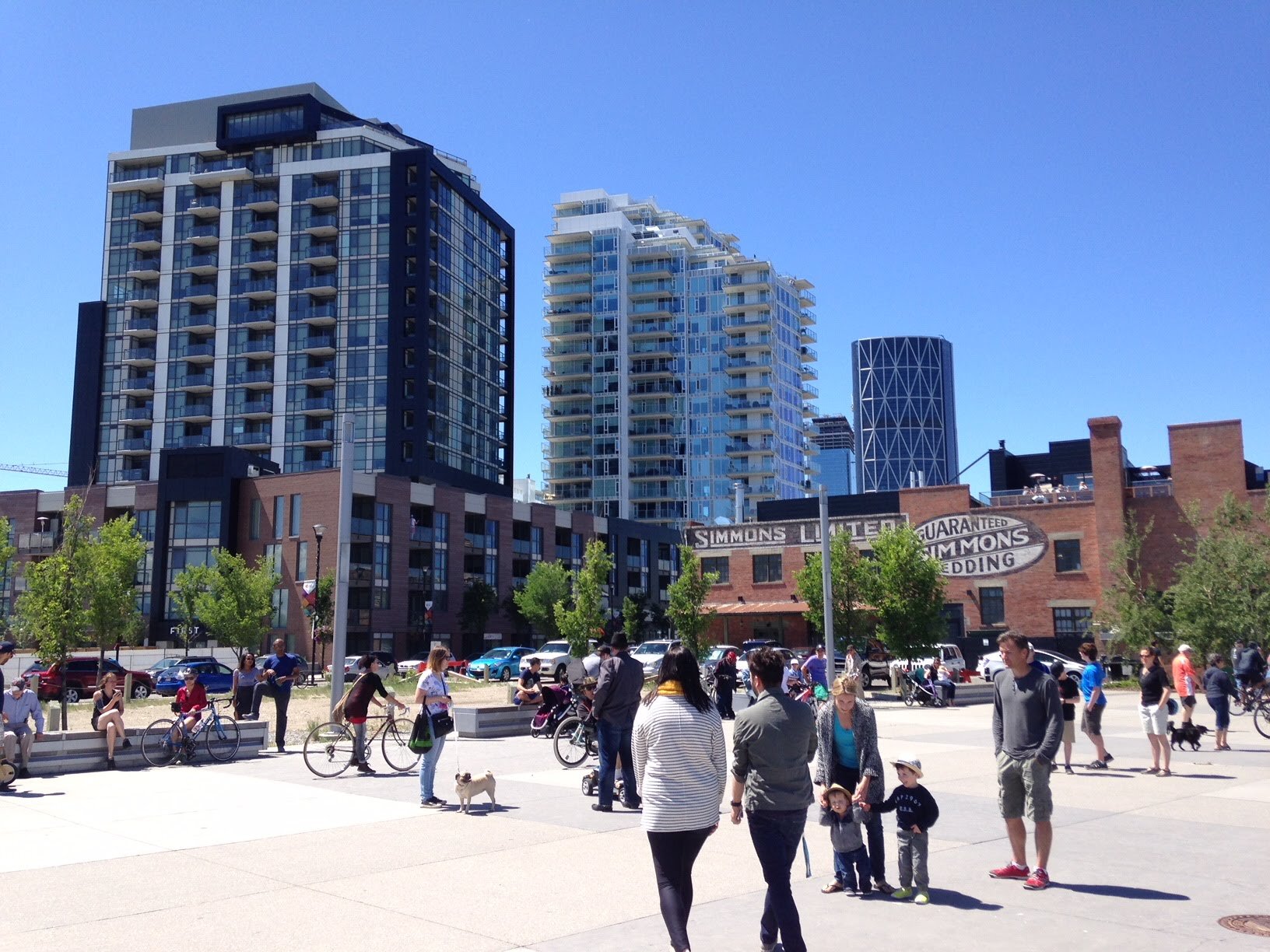
Continuing along the way you will find several lookout platforms, street art and sculptures before arriving at the historic Simmons Building, where you can get a Calgary-roasted Phil & Sebastian coffee, a tasty sandwich, something sweeter at Sidewalk Citizen Bakery, or an upscale meal at Charbar, which has a spectacular rooftop patio offering great views of the Bow River.
Immediately east of the Simmons building, sits the George C. King Bridge, sometimes called the skipping stone bridge, as its arches remind some of a stone skipping across the water. Cross the bridge and you will discover the exquisite St. Patrick’s Island that has been a public space since the 1880s. Today it has popular man-made pebble beach, playground, picnic and play areas and public art. It is a popular spot for those floating the river to end their trip.

RiverWalk as seen from the Charbar roof-top patio.

East Village is an outdoor gallery with numerous sculptures and street artworks.

George C. King bridge aka Skipping Stone Bridge connects the SoBow Trail with St. Patrick’s Island.
RiverWalk Plaza is a popular meeting and lingering place.

St. Patrick’s Island’s pebble beach.
Bow & Elbow Confluence
But let’s keep going, as the confluence of the Bow and Elbow Rivers awaits you. This is where Calgary was first settled in 1875 by the North West Mounted Police, who built Fort Calgary which grew into the Calgary Barracks and by 1914, a flourishing city was developing. The site eventually became an industrial area for the Canadian National Railway until 1974 when the City bought the site and in 1978, the Fort Calgary Interpretive Center opened.
In 2006 a three-phase revitalization and redevelopment plan was adopted. The first phase involving the restoration of the Deane house (one of Calgary’s best fine dining spots), restoration of the Hunt House and Metis Cabin (which was moved back to its original location from Calgary Brewery sit) have been completed. Phase 2, an interpretive art piece by Jill Anholt that references the walls of the original fort is also completed. Phase 3, currently underway includes an upgrade to the current museum and renovations of the 1888 Barracks.
But let’s not linger too long as we still have 5 km to go. Cross the Elbow River Traverse Bridge (opened in 2014) into Inglewood, Calgary’s oldest community, which today has many century old homes interspersed with modern new infills.

Fort Calgary Barracks

Don’t be surprise if you find some people fishing in the river.
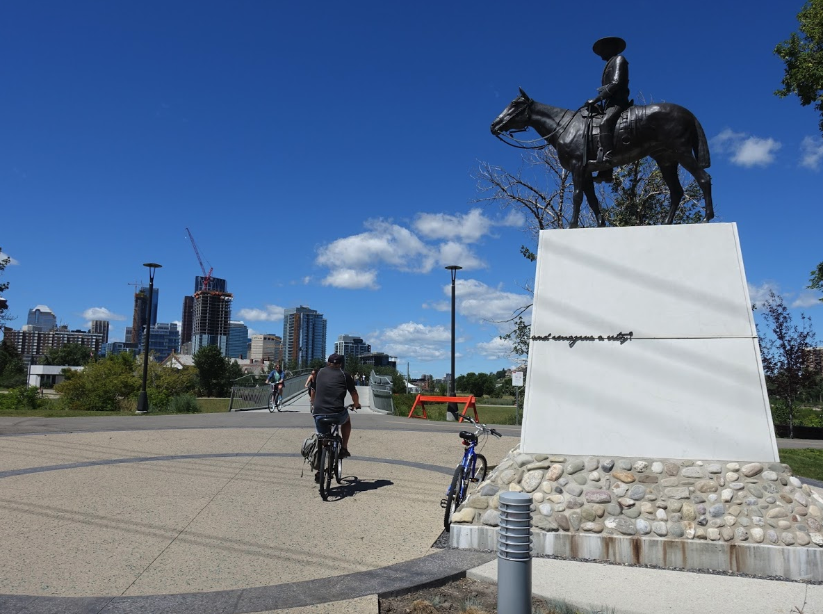
You will also encounter a major bronze sculpture titled “Mountie on Horseback” done by Harry O’Hanlon in 1995 for Fort Calgary but moved to this site in 2015. It is placed high-up on a plinth giving the Mountie a commanding view Fort Calgary the birthplace of Calgary.

Keep walking east and soon you will be at the new Zoo Bridge (opened 2017) that takes to the St. George’s Island and the Calgary Zoo and Botanical Gardens.

However we are heading east, but not before checking out “The Wolfe and Sparrows” sculpture by Brandon Vickerd, a piece inspired by the 1898 statue of General James Wolfe sculpture by John Massey in Calgary’s Mount Royal community. From a distance, it looks like a typical realistic figurative bronze figure, but get up close to see \ the top of the sculpture is actually a flock of sparrows. The piece was conceived based on many conversations with community members who wanted something historical, yet contemporary. (Ironically General Wolfe never visited Calgary and his fame as the victorious British general in the Plains of Abraham in Quebec City in 1759 has nothing to do with Calgary. In 1759, the confluence of the Bow and Elbow River was a temporary summer meeting place for local First Nations.)

Heading further east will take you through a nature area and eventual to Pearce Estate Park. This park, situated at the point where the Bow River takes a sharp turn south, is home to a large reconstructed wetland, as well as the Sam Livingston Fish Hatchery and the Bow Habitat Visitor Centre.
A trout pond allows kids to try their hand at fishing, while the Discovery Centre’s aquariums where allow you to come eye-to-eye with over 20 of Alberta’s fish species, as well as other educational displays and a theatre.
Proceed further and you find yourself at the 36-hectare Inglewood Bird Sanctuary where you can wander and see how many of the 270 different birds known to frequent the area (Bald Eagles and Osprey) you can find. The Nature Centre is currently being expanded with completion expected in September 2020.

The Sanctuary also includes the 1910 house of Colonel Walker, an officer of the first NWMP detachment that came to Calgary, who became one of the most influential civic figures in the City’s early years. He was declared Calgary’s “Citizen of the Century” in 1975. “Inglewood” was Walker’s name for his home and the moniker was soon applied by the public to the surrounding community.

The final destination is the Harvie Passage, a world-class white water passage recently rebuilt after the 2013 flood destroyed it. It now has two channels - one a low-water channel for inexperienced or novice rafters and paddlers and a high-water channel for experienced users. It is a place to see young kids developing their skills and Olympic calibre athletes perfecting theirs.

And don’t miss the impressive public artwork by Lorna Jordan. Titled “Bow Passage Outlook,” it looks like a bunch of railway ties tossed on a hill. Kids love climbing the sculpture; couples and families love to sit on the beams, which if you climb to the top, offers a great view at the top of the majestic Bow River.
The City of Calgary has a master plan called “Bend in the Bow” that will integrate the Inglewood Bird Sanctuary, the Inglewood Wildlands, Pierce Estate Park, River Passage Park and Harvie Passage into one regional park.
Last Word
The SoBow Trail is indeed a special place that deserves to be named and officially recognized as one of the best and most unique urban experiences in North America. It should be up there with San Antonio’s River Walk as a tourist attraction.
I love how SoBow Trail includes elements of Calgary’s past and present to create an urban sense of place within a nature setting. It is not a tacky contrived Disneyesque park, but something authentic and unique to Calgary.
It’s high time to start promoting the SoBow Trail to locals and tourists alike as a “must do” fun day activity.
See YOU on the SoBow Trail….
List of SoBow Parks, Plaza, Bridges etc:
Edworthy Park
Douglas Fir Trail
Lawrey Gardens
Pumphill Park
Nat Christie Sculpture Park
Shaw Millennium Park
Contemporary Calgary
Louise Bridge
The Wave
West Eau Claire Park
Peace Bridge
Prince’s Island Park
Eau Claire Plaza
Sien Lok Park
Centre Street Bridge
Jean & Jean Leslie River Walk
Reconciliation Bridge
RiverWalk Plaza
George King Bridge
St. Patrick’s Island
Fort Calgary
Elbow River Traverse Bridge
St. George’s Island / Zoo
Pearce Estate Park
Inglewood Bridge Sanctuary
Harvie Passage
If you like this blog, you will like these links:
A Brief History Of The Bow River Islands