
Calgary’s History: Why we live, work play where we do!
In every city’s evolution there are defining projects and champions who shape the City’s sense of place. I was inspired to trace Calgary key projects, decisions and individuals after reading the book “Citymakers: Calgarians After The Frontier” edited by Max Foran and Sheilagh Jamieson that explored 25+ individuals who helped make Calgary the city it was in 1987, when the book was published.
I thought it would be interesting to produce a concise history of Calgary’s urban development from 1875 to the present, to learn why we live, work and play where we do today!
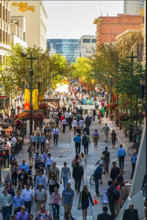
Stephen Avenue Walk aka 8th Ave SW has been a poplar place for downtown workers to stroll at noon hour for over 100 years. (photo credit: Jeff Trost)

The Calgary International Folk Festival at Prince’s Island is just one of Calgary’s many annual festivals that happen year-round thanks to thousands of visionaries and volunteers.
1875: Building of the Fort / First Nations / Ephrem Brisebois / Colonel James MacLeod

The confluence of the Bow and Elbow Rivers has been a significant meeting place for centuries - known as Mohkinsstsis (Blackfoot), Wîchîspa (Nakoda) and Guts’ists’i (Tsuut’ina).
The confluence of the Bow and Elbow rivers is mentioned in oral histories as a place of rest, trade, celebration, conflict and more.
However the story of Calgary as a permanent settlement begins in 1875 when the North-West Mounted Police decide they need another fort in Alberta and Ephrem Brisebois commander of “F” Troop decides it should be built at the confluence of the Bow and Elbow Rivers.
Brisebois wanted to called it Fort Brisebois, however Colonel James Macleod, suggested “Fort Calgary” after Calgary House, a castle at Calgary Bay on the Isle of Mull, Scotland. In the end, NWPM Assistant Commissioner, Colonel A.G. Irvine forwarded Macleod’s suggestion to the Department of the Interior in Ottawa and Fort Calgary became the name of the new fort in 1976.

1883 CPR defining Downtown / Achibald McVittie
CPR executives decided to build the Calgary train station west of Elbow River so they could profit by selling the bare land next to the station to businesses and residents. This was not popular with Calgarians who mostly worked and lived east of the river and assumed the station would be built there.
CPR Chief Engineer Herbert Holt asked post master James Bannerman to move the post office building from Inglewood to a site near the current Palliser Hotel in return for $100 and two lots. An agreement was reached and Holt put a rope around the post office building and dragged it across the frozen Elbow River to the station in the dark of night. When Calgarians woke up and saw their post office was on the other side of the river they soon followed.
FYI: It wasn’t until 1907 that Calgary’s grand railway station was built at Centre Street and 9th Avenue, followed by the Palliser Hotel in 1914. The railway station was demolished in 1966 to make way for the Calgary Tower and Palliser Square development, Calgary’s first failed attempt at downtown urban renewal.
Archibald McVittie, a land surveyor hired by CPR, was responsible for laying out the grid system of the avenues, going east and west and streets, north and south, as well as the size of the blocks. The grid system, the river and the railway defined how Calgary’s City Center would evolve, with downtown on the north side of the tracks and a warehouse district on the southside.
Fun Fact: The avenues of downtown and the Beltline don’t run true east and west, they are parallel to the railways tracks. If you look at Google Maps you can see how they converge near Tomkins Park, with 17thAvenue SW being the correction line to establish true east west avenue.

The Canadian Pacific Railway’s main line defines the southern boundary of Calgary’s central business district from the Beltline.
1885 Chinatown / Louie Kheong
There have been three Chinatown locations in Calgary. In 1888, Calgary’s Chinese residents were concentrated between 7 and 9 Avenues (mainly along 8 Avenue) between 2 and 4 Streets SE. But by 1901 a second Chinatown developed just south of the CPR main line mainly between 10 and 11 Avenues SW, and 1 and 4 Streets SW was built around a nucleus of Calgary’s first Chinese Mission at 215 10 Avenue SW. And by 1910 the Chinese migrated to the current Chinatown.
Today, Calgary’s Chinatown consists of approximately 49 acres bounded the Bow River on the north, Macleod Trail on the east, 2 Street SW on the west and 3 Avenue SW to the south, with a bump-out extending one block south along Centre Street South and two blocks east across 4 Avenue SE. The community boundaries also include the eastern portion of Prince’s Island.
Pioneer Louie Kheong (aka Luey) is considered the patriarch of Calgary’s Chinese community. He arrived in Calgary in 1894 and is believed to be the city’s first Chinese merchant. He established the Kwong Man Yuen store in Chinatown’s first location and provided a community room in the back in the 1890s.
He also protested the treatment of his compatriots in a letter to the Calgary Herald pointing out China treated Western missionaries and businessmen with respect. In 1905 he became the first Chinese Calgarian to bring his wife over, and the couple became parents of the first Chinese Canadian baby born in the city.
Kheong was one of the businessmen who built the original part of the Canton block in Chinatown’s third location (200–210 Centre Street SE, extant). Among his many leadership roles, Kheong was life president of the Sue Yuen Tong Society, president of the Chinese Masonic Lodge, the lodge’s Dart Coon Club and Calgary Chinese Refugee Society.
In 1984, the City developed the Chinatown Plan that included preserving the low density land use zoning to protect it from encroachment of downtown highrise office towers. The plan also secured land and funding for the Chinese Cultural Centre, thanks to the dedicated efforts of Victor Mah.
Chinatown and the Chinese community have played a significant role in shaping our city over the past 100+ years.

Today, Calgary is the third most ethnically diverse city in Canada.
1911 Horseshoe Hydro Plant

Recognizing that Calgary needed a reliable source of cheap power, Max Aitken (Lord Beaverbrook), Sir Herbert Hold, Richard Bedford Bennett formed the Calgary Power Company (which would become TransAlta Utilities) to build the first hydro plant on the Bow River.
Having cheap power was key to the Canadian Pacific Railway’s decision to set up its massive Ogden Shops on the east side of the city in 1913 that at its peak employed 5,000 workers.

Another key to securing the CPR maintenance shop was the City agreeing to extend the street railway to the shop and absolve the railway from obligations to construct underpasses in the downtown area. With the addition of the Ogden Shops Calgary achieved its dream of becoming a major railway hub.
The Ogden Shops, together with the Pat Burns slaughterhouse (1890) and a packing house (1898) and A.E. Cross and William Roper Hull’s founding the Calgary Malting and Brewing Co established in 1892, cemented Calgary’s east side as its industrial district.
It established Calgary’s east/west divide, whereby most Calgarians live on the west side of the city and work on the east side for the next 100 years.

Today Calgary is the major inland port for western Canada, integrating international rail, truck and air cargo shipping. Link: Calgary: A Major Inland Port City
1912 Central Memorial Library / Annie Davidson
Calgary boast one of the most robust library systems in North America. It is home to several signature library buildings, including the historic Memorial Park Library.

Annie Davidson
At 70 years old, Annie Davidson helped found and build Calgary's first public library.
Davidson and the Calgary Women's Literary Club gathered support for Alberta's first public library and obtained funding from the Carnegie Foundation to build the Memorial Park Library.
The City then hired Alexander Calhoun to be Calgary’s first chief librarian in 1911, a role he occupied until his retirement in 1945.
He was responsible for fostering Calgary’s culture that encompasses a love for reading and libraries.
Today, Calgary’s library system is consistently ranked as one of the top 10 busiest libraries in North America. And our new Central Library has been recognized internationally as one of the world’s great new libraries.
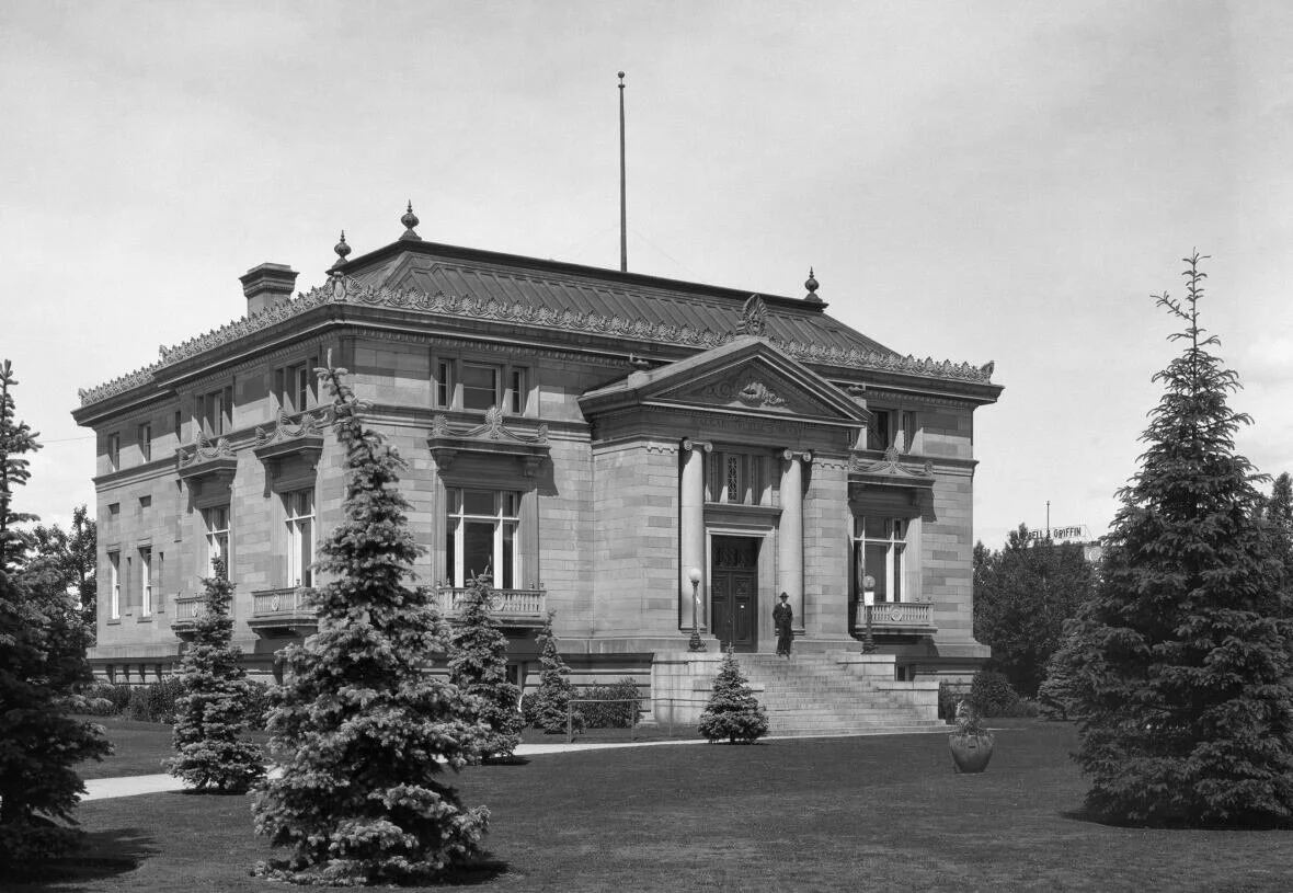
Memorial Park Library in the ‘30s…

Memorial Park Library today…
1912 Calgary Stampede / Guy Weadick

Stampede Park is home to one of the world’s most famous annual festivals - The Calgary Stampede.
Few cities have a signature event with international recognition as the Calgary Stampede.
Thanks to the vision of cowboy promoter Guy Weadick and four Calgary business men who put up the money for the first Calgary Stampede – Patrick Burns, George Lane, A.E. Cross and Archibald J. McLean. Calgary has enjoyed an international reputation for over 100 years.
The Calgary Stampede has evolved over the past 100+ years from an agricultural exhibition and rodeo to a mega entertainment festival that includes major music concerts, an outdoor stage show, as well as, a First Nations gathering.
Over the same period, Stampede Park has evolved into Calgary’s major sports and entertainment district.
The Big Four building was once the largest curling facility in the world with 48 curling ice sheets (24 on each floor).
It has also been home to Calgary’s hockey and major events, with The Coral, Saddledome and Round-Up Centre (now BMO Centre). The grandstand was Calgary’s home for horse racing for decades.
Today, Stampede Park is undergoing a massive billion dollar makeover that will make it a year-round 21stcentury sports, meeting and entertainment district, with a new arena, expanded convention, trade show event center, a themed main street and upgraded LRT station.
Stampede Park is the soul of the city, while downtown it its heart.


Calgary Stampede Midway (photo credit: Peak Aerials)
1913 City of Parks & Trees / William Reader
William Reader was appointed as the city of Calgary’s third Superintendent of Calgary Parks, Cemeteries & Recreation in 1913. Not only was he responsible for development of Central Memorial Park, Reader Rock Gardens, Riley Park and Union Cemetery, but also for the planting of tens of thousands of trees.
Calgary’s arid, prairie climate was all grasslands except for patches of trees along the river banks 100 years ago, but Reader was a “City Beautiful Movement” champion. Advocates of the philosophy believed beautiful streets and public spaces could promote a harmonious social order that would increase the quality of life of the citizens.
Today Calgary is home to not only 5,600+ parks, including two of the largest urban parks in Canada – Fish Creek and Nose Hill (both are significantly larger than Vancouver’s Stanley Park) but 7,000,000+ trees.
Thanks to Reader, all of Calgary’s older communities have beautiful tree canopies.


Sunalta is just one of Calgary’s early 20th century communities blessed with a lovely tree canopy a 100 years later.

Over the past 100+ years, Calgary has become a lush urban forest. (photo credit: Peak Aerials)
1914 Oil Capital of Canada / Archibald Dingman

The Turner Valley Dingman No 1 well site struck a petroleum zone on May 14, 1914, which ultimately shifted Canada’s oil and gas industry from southern Ontario to Alberta. Calgary Petroleum Products Co. Ltd. was formed in 1915 with Archibald Dingman as the Managing Director, other Directors included, A.E. Cross, A.J. Sayre, W.M. Pearce and T.J.S. Skinner.
However it went bankrupt in 1920 and was taken over by Royalite Oil Company which subsequently became part of Imperial Oil.
In 1936 a Turner Valley Royalties No. 1 well hit a deep pocket of oil near Longview that ultimately produced 10 million barrels of oil a year (95% of Canada’s oil and the most productive oil field in the British Empire) solidifying Calgary as Canada’s Oil Capital, long before the Leduc find near Edmonton in 1947.
Link: Calgary’s History as Canada’s Oil & Gas Capital
1919 SAIT/PITA Dr. Thomas H. Blow
When Edmonton was chosen to be the capital of Alberta, Calgary assumed it would get the university, but that didn’t happen, it went to Strathcona, which was later annexed by Edmonton.
In 1909, Dr. Thomas H. Blow a Calgary physician initiated a lobby for the establishment of a university in Calgary. By 1912, Calgary College had been established to train teachers, but had no degree-granting powers. Blow first tried, to have the college affiliated with Queen University, but failed.
He then became a Conservative member of the Alberta Legislative Assembly in 1913 and petitioned the provincial government to establish a commission to report on the status of Calgary College as a degree granting institution. The commission recommended the establishment of the Provincial Institute of Technology and Art (PITA) and against giving Calgary College the power to grant degrees.

SAIT campus with the historic Heritage Hall juxtaposed with the new glass entrance to a parkade, with a playing field on the roof.
The permanent home for what is today called Southern Alberta Institute of Technology happened in 1919, when the Province purchased 110-acres of land on the North Hill from the Riley family as a permanent home for what was then commonly referred to as “The Tech”, for $63,000.
Additional land was obtained from Thomas E. Riley for the construction of the Main Building (Heritage Hall) in return for the Province pardoning the $30,000 he owed in back taxes.
PITA was the catalyst for the northwest to become Calgary’s learning quadrant as it eventually became home to Alberta University of the Arts (Alberta College of Art Design), University of Calgary and two teaching hospitals (Foothills Medical Centre and Alberta Children’s Hospital).

SAIT Campus (photo credit: Peak Aerials)
1929 Glenmore Dam/Reservoir / Gore, Naismith, Storrie Water Supply Report
In the 1920s, the City retained architects Gore, Naismith and Storrie to study the inadequate and frequently contaminated water supply. In their 1929 report they made 12 recommendations including the Glenmore Dam and Reservoir.
The City obtained approval from the Government of Canada under the Irrigation Act and then undertook a plebiscite during the 1929 election to approve a bylaw to borrow the $2.77 million for the dam and other waterworks improvements.
With the approval of the bylaw the City began purchasing the required land including 540 acres from the Tsuut’ina Nation for $50/acre, totalling $29,675. The purchase was negotiated by city solicitor Leonard Brockington, who was given the name “Chief Weasel Head” to ensure the traditional name of the area would live on. Other landowners in the area were paid between $111 and $400 per acre.
However, due to growing costs and questioning of contracts, a judicial inquiry headed by Supreme Court of Alberta Justice Albert Ewing took place in 1932. Ewing found no wrong doing and the dam became operational on January 19, 1933.
The project also included the brick and stone Art Deco Glenmore Water Treatment Plant, that features distinctive ‘porthole’ windows and sleek marble-clad, terrazzo and tiled interiors. The building was declared an American Waterworks Association landmark in 1992 and is was protected as a Municipal Historic Resource in 1992. It is one of Calgary’s hidden architectural gems.
The legacy of this project is that today Calgary boasts some of the best water treatment facilities in North America, which results in having the best tasting tap water and cleanest rivers of any major city in North America.
It also created a huge recreational space in the middle of the city, with parks on both the north and south sides, a golf course, as well as creating opportunities for sailing, rowing and canoeing in the middle of the city.

Glenmore Reservoir (photo credit: Peak Aerials)

The reservoir is used for various water activities.
1954 Calgary’s Unicity Model / George McNally
As Calgary continued to grow in the first half of the 20th century, so did the towns around it – Bowness, Montgomery, Forest Lawn, Beddington and Midnapore. In the early 50s, the province appointed George McNally to head up a committee to look at different growth models for Calgary and Edmonton regions. McNally had been the Provincial Deputy Minister of Education and former Chancellor of the University of Alberta.
McNally’s recommended both Calgary and Edmonton should adopt a uni-city model where by annexing neighbouring villages and towns to create one large city as boundaries met.

Calgary adopted the uni-city model, by annexing Forest Lawn and Midnapore in 1961, Montgomery in 1963 and Bowness in 1964 and Beddington in 1975 and has continued to annex land as needed to allow for continuous development – residential, commercial and industrial.
As a result, Calgary has becomes one of the largest geographical cities under one elected Council in the world at 800+ square kilometers.
Unlike other North American cities, Calgary has been developed in a more or less continuous manner, rather than having fragmented growth with multiple cities, towns and villages competing with each other for business development and duplication of services.
1958 Suburban City / Tony Ussleman, Albert Bennett and E.V. Keith

In 1958, 45 Calgary home builders came together to create a mega home builder corporation called Carma Developers.
The major shareholders were Tony Ussleman and Albert Bennett who each owned 20% of the company. Carma was responsible for building 60 new communities including its first community – Rosemont.
Carma grew to become a huge home builder not only in Calgary but other cities and was acquired by New York City’s Brookfield Properties in 1987, with Calgary becoming the headquarters for Brookfield Residential.
Another influential home builder was Keith Construction who were responsible for Canada’s first urban lake community - Lake Bonavista in 1968, followed by Lake Bonaventure. Today Calgary is home to a dozen different lake communities.
Other key developers who have shaped Calgary’s suburbs over the past 50+ years include Jim DeWald, Mark McCullough, Ron Noland, Alan Norris, Randy Remington, Ralph Scurfield and Jay Westman.
Not sure which came first, Calgarians demand for single family homes or home builders demand for home buyers. No matter, Calgarians love home ownership more than any city in Canada – 73% of Calgarians own their own home, compared to just 66% in Toronto, 64% in Vancouver and 56% in Montreal. And, perhaps the world, only 33% of Parisians own their own home, 37% in Berlin and 51% in New York City. Home ownership plays a significant role in defining Calgary’s unique culture and sense of place.

Lake Bonavista and Lake Bonaventure (photo credit: Peak Aerials). Note all the trees that have been planted to convert the prairie grasslands into an urban forest.
Today Calgary boasts 160+ community associations, representing 200+ neighbourhoods each with their own character and appeal. The first association dates back to 1908 in Bridgeland-Riverside.
Today these Community Associations are responsible for fostering a diversity of vibrant neighbourhoods in the city centre, inner-city and new suburbs.
While some urbanists are critical of Calgary’s suburban sprawl, our city partly because of its uni-city governance model, continuous pattern of growth and active Community Association is ranked as one of the best places to live in the world.
Link: The Role and Future of Calgary’s Community Associations

1956 / 1977 Open of New Airport terminal building
Calgary’s first airport was in Bowness in 1914. It moved to the present day airport site (originally called McCall Field) in 1938, under the ownership of the Federal Government of Canada. It began expanding in the early ‘50s with the increasing popularity of flying for business and personal travel, as well as cargo transportation. It included five large aircraft hangers that were widely used by the Royal Air Force. Canadian Pacific Airlines officially began flights between Calgary and other Canadian cities in the mid ‘50s.
In 1956, a new airport terminal opened making it Canada’s most advanced and modern airport facility - it served Calgary’s needs for the next 21 years.
In 1977 the new terminal was opened and Transportation Canada began work on developing a plan to ensure the land and roads near the airport would allow for future expansion.
This was the beginning of the creation of Calgary’s northeast quadrant as Calgary’s Airport City with mega warehouse and distribution centers, similar to how Mississauga is Toronto’s airport hub and Richmond is Vancouver’s.
In 1996, West Jet was founded by Clive Beddoe with three aircraft, five destinations, until COVID hit it flew to 100+ destination, with 22 million passengers and had over 14,000 employees.
Calgary has been a transportation hub since the arrival of CPR in 1883, and the completion of the Trans-Canada Highway in 1962. By the end of the 20th century, Calgary was also a major airport hub.
Fun Fact: There was also a municipal airport in Renfrew from 1928 to 1938. One of the hangars still exists.

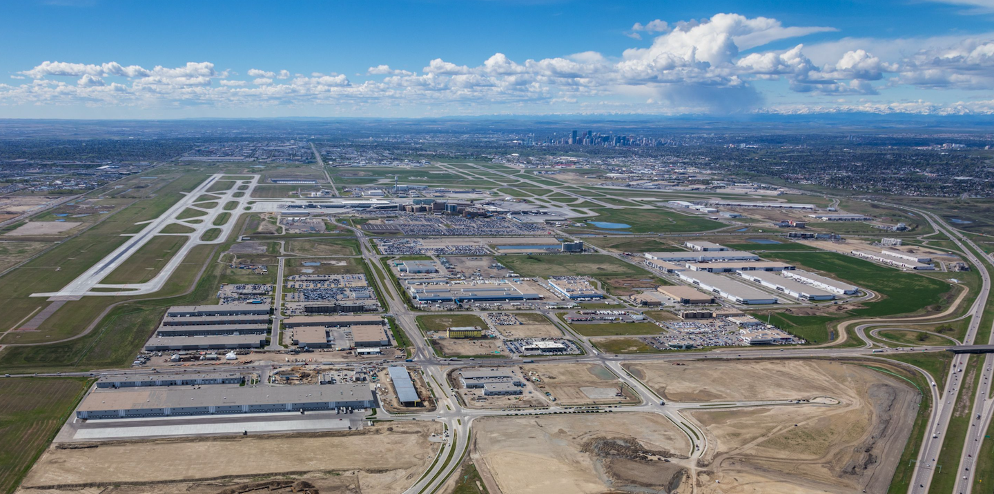
Today the Calgary International Airport is the major passenger and cargo airport hub for the prairie provinces. (photo credit: (Peak Aerials)
1966 University of Calgary / Grant MacEwan
The history of the University of Calgary can be traced back to establishment of the Normal School in Calgary to train teachers in 1905. As part of post-WWII reconstruction, the provincial government decided to bring all teacher training in the province under the aegis of the University of Alberta (UofA). As a result, in 1945, the Calgary Normal School (teachers college located at SAIT since 1923) )became the Calgary branch of the UofA’s Faculty of Education.

By the early ‘60s as a result of UofA continuing to expand its Calgary programing, a complete branch campus was formed, known as University of Alberta at Calgary (UAC). This ended in 1966 when the University of Alberta became an autonomous institution.
Grant MacEwan a Calgary MLA from 1955 to 1958 and Alberta Liberal Party Leader from 1955 to 1960 was one of the champions of Calgary university.
He continued his lobbying as the mayor of Calgary from 1963 to 1965 and then as Alberta’s 9th Lieutenant Governor from 1966 to 1974.
Fun Fact: In 1957, the University of Alberta signed a one dollar lease with the City of Calgary for 300 (acres) of land at the west edge of the city for a university campus. In 1958, the site became known as “University of Alberta in Calgary” and plans were unveiled for a future campus that never happened.

University of Calgary campus (photo credit: Peak Aerials)
1966 – The Glenbow / Eric Harvie

The Glenbow was founded in 1966, when Eric L. Harvie a Calgary oilman and philanthropist donated his massive collection of art, artifacts and memorabilia to the people of Alberta and the Glenbow-Alberta Institute was formed to manage the collection.
In 1976, the 8-storey building with three floors of exhibition space (8,361 square meters) opened as a new anchor on downtown’s historic Stephen Avenue, along with a convention centre and new hotel. Calgary’s second failed attempt at downtown urban renewal.
The Glenbow (as it is now branded) is Western Canada’s largest museum and one of the largest collections of arts and artifacts in Canada – 192,000 objects, including 26,000 pieces of art and 28,800 pieces in the mineralogy collection.
Eric Harvie’s donation, which lead to The Glenbow on Stephen Avenue was the impetus for the creation of an arts district at the east of Stephen Avenue that would eventually include Arts Commons, Olympic Plaza, Lunchbox Theatre and Vertigo Theatre and for a while Triangle Gallery and Art Gallery of Calgary.
1969 Calgary Pathway System / Harry Boothman
Harry Boothman assumed the role of Parks Superintendent in 1959 and fundamentally changed the way Calgary managed its parks. He was less interested in making parks look beautiful and all about letting people use them.
Rumour has it one of his first initiatives was to remove all of the “keep off the grass” signs that were common in city parks and replace them with “please enjoy the grass” ones. He also recognized the need to connect parks and open spaces to each other with a network of pathways and scenic boulevards.
In 1969 the Chinook Trail Association built a dirt path along the north side of the Bow River, from the Zoo to the Bearspaw Dam, to accommodate horses and pedestrians. Then in 1970, Boothman accessed funding from the federal government’s “Opportunities for Youth” program provided to design and build a trail along the Elbow River from the Bow River to the Glenmore Reservoir for pedestrians and cyclists, as well as horseback riding.
This was the beginning of Calgary’s city-wide multi-use pathway system linking Calgary’s 200+ communities, including the Parks Foundation Calgary’s 138-km Rotary Mattamy Greenway.

Confederation Park today.
1969 Performing Arts Centre / Dr. Martha Cohen, Sandra LeBlanc, Vera Swanson
In 1969, the need for an arts centre in Calgary was identified by the Calgary Philharmonic Orchestra, Theatre Calgary and Alberta Theatre Projects. In 1976, The Calgary Centre for Performing Arts (CCPA) was officially registered as a charitable organization. Three women were instrumental in establishing and raising funds for the Centre - Dr. Martha Cohen, Sandra LeBlanc and Vera Swanson. They were successful in raising $102.4 million to build of one of the largest performing art centers in North America.

Sandra LeBlanc, Martha Cohen, Vera Swanson celebrating the opening of the Calgary Performing Arts Centre in 1985.
Federal: $2.5 million
Provincial $48.7 million
City site value $12.3 million
City of Calgary $12.7 million (grant)
Private Sector $11.3 million
Interest $14.9 million
On September 14, 1985, the CCPA was officially opened with a televised gala celebration. The entire building was wrapped in red ribbon, which was cut by Dr. Martha Cohen, Vera Swanson and Sandra LeBlanc.
In 2001, the Centre’s name changed when EPCOR Utilities Inc. entered into a ten-year naming agreement with EPCOR CENTRE for the Performing Arts. In 2014, the Centre rebranded to Arts Commons, representing “the Arts” which expands its offering beyond the performing arts to a wider variety of arts and genres.
“Commons” is derived from the old town square concept where ideas are shared, people from all walks of life gather, and different perspectives are welcomed. While some thought it was a perfect name for the complex, others were confused.
FYI: Arts Commons is currently looking at a $400+ million expansion and renovation initiative.
1971 New Alberta Premier – Peter Lougheed
Lougheed, perhaps more than any other Alberta Premier helped shape Calgary’s sense of place. During his tenure Deerfoot Trail was expanded to become not only a major freeway for Calgarians, but a major North American transportation route that ultimately allowed Calgary to become a major Inland Port (rail and trucking).
He was also instrumental in the success of the XV Olympic Winter Games (commonly known at the 1988 Calgary Olympics), by providing guaranteed upfront funding for Olympic facilities when the Federal government funding was delayed. The Olympic Saddledome would not have been built without his support. He was also responsible for approving the creation of a provincial park within the boundaries of the city - Fish Creek Park.
Lougheed was also very supportive of Calgary’s early LRT development – South Leg in 1981 Northeast Leg in 1985 and Northwest Leg in (1987). Under his leadership the Province provided the majority of the funding for Calgary’s first three legs of the LRT.

By the late ‘80s Calgary not only boasted one of the most extensive LRT systems in the world, but one of the highest riderships in the world.
The creation of the 7th Avenue transit corridor as the hub of Calgary’s transit system has shaped the city’s development for the past 40 years.
Today 7th Avenue is home to many of Calgary’s important buildings and public spaces – City Hall, Library, The Bay, The Core, Brookfield Place, Telus Sky, Nova Building, Olympic Plaza, Century Gardens, The Bay, Devonian Gardens, Contemporary Calgary and Shaw Millennium Park.
Lougheed was also a huge supporter of arts in Calgary with his government providing almost half of the $100+ million funding for Calgary’s performing arts centre which opened in 1985.
Funny story: Lougheed used to say he knew when he had a meeting with Dr. Martha Cohen, Sandra LeBlanc and Vera Swanson, they wouldn’t leave until he had cut them a cheque.
1971 Spruce Meadows / Southern Family
The Southern Family purchased a former feedlot south of the city in 1971, with the first riding hall being constructed in 1973 and the grand opening of Spruce Meadows in 1975. The first two equine events, The National and the Masters took place in 1976. The ‘80s saw rapid expansion that culminated in annual prize money of over $1 million in 1987 and the royal visit of Her Majesty Queen Beatrix of the Netherlands in 1988 and Her Majesty Queen Elizabeth II in 1990. There was continued expansion in the ‘90s, with the first $1 million Grand Prix in 2000 and in 2002 Spruce Meadows is voted the #1 Outdoor Show Jumping Venue.
Spruce Meadow also started to diversify its programing with the first International Christmas Market in 2001, which grew to become a very popular Christmas Market Lights at Spruce Meadows by 2011. In 2019 a soccer stadium was built as the home for the Cavalry FC soccer team.
Today, Spruce Meadows is a 505-acre multi-purpose sports facility that attracts over half a million visitors a year and millions more on TV. Like the Stampede it draws international visitors and attention to our city. Calgary now has two of the greatest outdoor shows in the world. Open 365 days of the year, it has become the premier cultural/entertainment facility for Calgarians living south of Fish Creek Park.
FYI: Spruce Meadows has been built by the Southern Family without any government funding. One of its defining features is that most of its events are free or nominal admission fee.

Ron and Marg Southern

Spruce Meadows is considered to one of the top 3 equestrian complexes in the world.
1973 Nose Hill / Fish Creek Parks / Rosa Gorrill / Roy Farran / George Cornish
In 1962, the Calgary Local Council of Women proposed two major green spaces be set aside in Calgary - Nose Hill and Fish Creek. However, the creation of the parks didn’t happen easily.
FYI: The Local Council of Women in Calgary was organized in 1894 by Lady Lougheed, although it did not become firmly established until 1912.
Private Citizen Mrs. Rosa Gorrill initiated the formation of the Fish Creek Association as there was pressure from Kelwood Corporation to allow for housing development and a road along the north escarpment, but Gorrill and group pushed for no road and only limited development.
City Planner Michael Rogers also thought the creation of Fish Creek Park was a good idea after the city annexed the village of Midnapore in 1962, but the Council rejected the idea. Fortunately Alderman Roy Farran nurtured the idea and when he was elected as MLA in 1971, he advocated for Fish Creek Park. Finally in 1973 the Province announced they were creating a 2,850 acre provincial park in the valley and escarpment of Fish Creek from 37th St to confluence with the Bow River.
Also in 1973, Calgary’s City Council voted to reserve 4,100 acres of Nose Hill as civic parkland. However, that was reduced to 2,600 acres in 1976 and then in 1977 Glen Abby Corporation and United Management purchased 700 acres and began planning a new community. Fortunately, 10 local communities organized a 5,000 name petition to oppose the development and won.
From 1980 to 1988, there was continued pressure to develop some of the land earmarked for the park. Finally, in 1989 George Cornish City of Calgary Engineer / Chair of Nose Hill Task Force proposed to retain Nose Hill Lands as public open space in perpetuity. City and Province agree to share cost of the $26.6M purchase of land from landowners and 2,600 acre park was realized (1052 hectares).
Today Calgarians not only get to enjoy two of Canada’s largest urban parks, but the 5,600+ parks and green spaces scattered across the city. You could visit a new park or green space everyday for 15 years and not see all of them.

Nose Hill Park Siksikaitsitapi Medicine Wheel. Link: A Walk In The Park: Stanley Park vs Nose Hill
1983: Lindsay Park Sports Centre / John Currie
Calgary hosted the Western Canada Summer Games in 1983, and one of the legacies of the games was the Lindsay Park Sports Centre (now the Repsol Sports Centre) with its futuristic domed white roof. John Currie, the President of the Games was a key figure in the development and funding of the advant guarde building.

Repsol Sports Centre’s unique design and success resulted in Calgary boasting some of the best recreation centres in Canada.
The success of the Lindsay Park Sports Centre and two other early ‘80s recreation centers (Village and Southland Leisure Centres) were the catalyst for the City of Calgary in partnership with communities and developers to build several major regional multi-purpose recreational facilities that would become indoor suburban town centres.
These include: Westside Recreation Centre (2000), Cardel Place (2004), Genesis Centre (2012), Great Plains Recreation Facility (2016), Shane Homes, YMCA at Rocky Ridge (2018) and Brookfield Residential YMCA at Seton (2019).
FYI: The SETON and Rocky Ridge YMCAs are the #1 and #2 largest YMCA’s in the world.

Shane Homes, YMCA at Rocky Ridge (2018)
1988 Winter Olympic Frank King / Ralph Klein / Bill Pratt
Calgary’s 1988 Winter Olympics happened only after failed attempts by the Calgary Olympic Development Association (CODA) to host the 1964, 1968 and 1972 Winter Games. CODA became dormant after the third failed attempt, until Frank King revived it in 1979. King spent two years building local support and selling 80,000 memberships to Calgary’s 600,000 residents.

Frank King / Ralph Klein
CODA secured $270 million from the federal and provincial governments and the support of then Mayor Ralph Klein who was instrumental in wooing the International Olympic Committee delegates in advance of their decision to award the 1988 Games to Calgary in 1981.
Bill Pratt took on the role as head of the Calgary Organizing Committee in 1983 and was responsible for getting all of the venues built in time for the games including the Calgary venues - Saddledome, Olympic Oval, Olympic Plaza, and Canada Olympic Park etc.
Like the Stampede and Spruce Meadows, the 1988 Olympics put Calgary on the map internationally. And the Saddledome became the home of the Calgary Flames who are ambassadors for our city across North America.
Lesson learned: If you don’t succeed at first, try, try again.

Olympic Plaza has become home to numerous festivals, winter skating, summer wading pool and it is where Calgarians come to celebrate.
2002 EnCana The Bow / Gwyn Morgan / David O’Brien
The merger of Alberta Energy Company and PanCanadian Energy corporation resulted in the formation of EnCana Corp, Canada’s biggest natural gas producer. In 2005, Encana hired international ‘starchitect’ Norman Foster to design the largest office tower west of Toronto, to be their WOW headquarters. It had to be taller, bigger and have more prestige than any other building in Calgary. It would become The Bow, with its unique curved shape reflecting the Bow River’s shape as it curves around downtown. When completed in 2012 it also included two public artworks by internationally famous artist Jaume Plensa who lives in Barcelona.
This building started a trend in Calgary both privately and publicly of hiring internationally famous architects and artists to design signature buildings, structures and public art in Calgary.

Telus Sky in foreground, The Bow in background.
2008: Broadway Malyan, East Village Master Plan (London, UK)
2011: Eight Avenue Place by Pickard Chilton Architects (USA)
2012: Peace Bridge by Santiago Calatrava (Spanish, lives in New York City)
2012: Promenade artwork by Julian Opie (London)
2014: George King Bridge by RFR SAS Partnership (Paris)
2016: St. Patrick’s Island Park by Civitas Inc. (Denver)
2017: National Music Centre by Allied Works Architecture (Portland)
2017: 707 Fifth by SOM Architects (Chicago)
2017: Brookfield Place, Arney Fender Katsalidis (London)
2018: Central Library by Snohetta (Oslo)
2018: Trio artwork by Christan Moeller (Los Angeles)
2020: Telus Sky by BIG architects (Copenhagen)
2021: West Village Towers by Yahya Jan, Norr Architects (Dubai)
2024: BMO Center expansion by Populous (Kansas City)
2026: New Arena by HOK (24 office on three continents)
2007 Formation of Calgary Municipal Land Corporation / Mayor Bronconnier
After decades of failed attempts to redevelop East Village, new mayor Dave Bronconnier convinced City Council to establish the Calgary Municipal Land Corporation (CMLC) as an arms-length body to manage the development of underutilized land on the east side of the City Centre. It was branded as the Rivers District.
CMLC under the leadership of first Chris Ollenberger, then Michael Brown and now Kate Thompson has been successful in creating and implementing the East Village Master Plan. CMLC has fostered several major public projects – RiverWalk, St. Patrick’s Island Enhancements, 4th Street Underpass, public art and new Central Library. CMLC has also attracted nearly three billion dollars in private investment in East Village.
Today CMLC, in addition to managing the redevelopment of East Village, is also managing the creation of the Rivers Entertainment Cultural District at Stampede Park, including the design and building of a new arena, major expansion of BMO Centre, creation of a main street along 4th St. SE and attracting one or more new hotels to the district. As if that wasn’t enough it is also managing the Arts Commons transformation downtown.
In many ways the future of Calgary’s City Centre is in the hands of CMLC.

CMLC is currently in the middle of implementing the redevelopment of Calgary’s East Village.
Key Planning & Policy Documents
Calgary’s sense of place is also influenced by key planning and policy documents that govern what gets built where. Here are some of those documents.
1914 Mawson Plan
Thomas Mawson was an internationally famous English town planner and landscape architect who developed a grand plan in 1914 that envisioned Calgary as Vienna on the Bow. The vision had The Bow River at Prince’s Island as its epicentre, with today’s 4th Street SW as its grand north/south boulevard. Ninth Avenue along the rail tracks where the Palliser and CPR Station were already built was a grand east/west boulevard. The plan called for Prince’s Island to have numerous museums, like river islands often do in Europe and downtown to lots of grand buildings like The Bay. The banks of the Bow and Elbow rivers would become boulevards like those along the Seine. Mawson envisioned Calgary growing to a city of million people. It even including a ring road.
The Bay arcades and Central Memorial Park are remnants of the Mawson’s grand plan. Similarly the curved streets and park-like design of Mount Royal and Scarboro, are in the spirit of Mawson’s grand vision. While the parks and pathways along the Bow and Elbow River are not exactly what Mawson proposed, they have become special public spaces for Calgarians. Prince’s Island, along with St. Patrick’s and St. George’s Island have become very popular public spaces - festivals, recreational and zoo respectively. William Reader’s parks and tree planting initiatives were also influence by the Mawson Plan. One could even imaging that pedestrian enhancements of Barclay Mall (3rd St SW) Stephen Avenue (8th Avenue) are linked to the Mawson Plan.
While Calgary didn’t become a European city like Mawson planned, the plan is often referenced when the city is conducting a visioning exercise, it was an inspiring vision and perhaps it has had more influence than we realize.
Fun Fact: CPR hired Fredrick Olmstead who was the most famous landscape architect in the world early in the 20th century to design their new housing developments – Mount Royal and Scarboro. Olmstead designed New York City’s Central Park and Mount Royal in Montreal.

1966 Downtown Plan
In many ways this plan shaped the downtown we have today, with large city owned parkades at the four corners of downtown, with a +15 system connecting them to the downtown core as a means of keeping cars out of the core. It also resulted in the cash-in lieu parking program that limited private parking underneath new downtown office buildings to promote transit use, specifically LRT and to fund more public parking, managed by the Calgary Parking Authority.
It included a bonus density program that resulted in downtown’s extensive +15 system and 100s of public artworks. It was responsible for downtown’s one-way street network, Stephen Avenue and Barclay Malls.
One of the things that didn’t happen, which was a good thing, was the creation of a downtown expressway along the Bow River that would have destroyed Eau Claire, Chinatown and the Bow River’s south bank. Learn more: Bow River Promenade vs Downtown Penetrator.
This plan was produced by Mike Rogers as Director of Planning, with support from Stu Round and Harold Hanen (who championed the +15 concept).


1971 Airport Land Use Guidelines
1979 Airport Vicinity Protection Area
These two documents dictated what can and cannot be built in on the land and communities under the flight paths of the Calgary International Airport. In 1971, Art Froese wrote the first comprehensive Airport Land Use Guidelines in North America.
These forward looking guidelines were the catalyst for transforming Calgary’s Northeast Quadrant into our Airport City.
It allowed the Airport to become a major air cargo distribution centre and the lands around it to become large distribution hub.
In addition, it foresaw the need for future airport passenger expansion, including a second runway. It restricted residential development next to the airport which resulted in Calgary being one of the few cities in North America to have a major airport within its city limits.
1981 Calgary River Valley Plan

Carburn Park
Initiated in 1978, the Calgary River Valley plan and policies were approve in 1981. It was a comprehensive plan that recommended the acquisition of 1,101 acres of land for regional parks and recreational facilities in the river/creek valleys at a cost $105M to purchase and develop the land to be shared by the City and Province.
The improvements included reducing potential flood damage and to facilitate the development of the river pathway system city-wide, as well as parks like Bowmont, Carburn Park and Cominco Lands.
This plan was instrumental in stopping planned river crossings at Shaganappi and Sarcee Trail in the ‘90s, which resulted in increased traffic on Crowchild Trail and the need for the ring road.
Bill Milne was a major champion for the creation of the Rivers Valley’s Plan and its implementation.
1983 BRZ Legislation

In June 1983, the Government of Alberta amended the Municipal Government Act to allow municipalities to enact a bylaw to establish Business Revitalization Zones (now known as Business Improvement Areas, as a result of new 2016 legislation).
Calgary’s first two BIA’s were formed in 1984 - 17th Avenue BRZ and South Calgary BRZ (now Marda Loop). A BIA can be formed when 25% of the businesses within a given area decide they would like to work together to collectively enhance their businesses. It is not a city initiative.
Today Calgary has 15 Business Improvement Areas (BIAs) whose mandate is to enhance economic development along a main street or in a defined commercial district. The BIA’s are financed by a local improvement tax on the businesses (not residents) in the area. They fund projects ranging from murals, banners, flowers and street furniture, to marketing and safety programs.
In almost every case, communities next to a BIA have experienced tremendous urban renewal, which has increased the property tax base for the city. The BIAs have been instrumental in the preservation of Calgary’s historic main streets and created vibrant pedestrian streets for all Calgarians to enjoy.
Link: Map Calgary BIAs
1995 Sustainable Suburbs Plan
This plan introduced the idea that new suburbs should have a mix of housing to double the density of suburban development. It also introduced the idea of neighbourhood nodes for commercial development with a mix of uses. Transportation networks were introduced to ensure that transit stops at community centers, schools and neighbourhood nodes.
In total, 41 design criteria were developed to evaluate suburban developments including natural drainage and storm water management. This plan also allowed for lane homes and secondary suites in new communities. Its implementation began almost immediately with the redevelopment of Canadian Forces Base Calgary redevelopment that included Garrison Woods, Garrison Green and now Currie, as well as Quarry Park.
Today, all of Calgary’s new communities are twice as dense, more diverse housing types and more mixed-use than those built in late 20th century.

Today new suburban housing looks very similar to infill housing that is happening in inner-city communities. There is lots of row housing, garages in the alley and narrow lots, mixed with multi-family and single family homes of various sizes.

These maps illustrate how Calgary’ new communities are being built at a much higher density than those in the last 20th century. Note many of the new communities are still in the building stage so they will get even denser in the future.
Last Word
I have tried to create a concise history of the people, projects, decisions and documents that have shaped Calgary’s sense of place, which means I had to leave out lots of interesting decisions and people.
There are numerous philanthropists who could have been included – Geoffrey Cumming, Don Taylor, Harley Hotchkiss, Doc Seaman, Ron and Fred Mannix and Ron Matheson all come to mind immediately, but there are thousands more.
I apologize that the document seems to be male dominated but the past being the past, it was men who dominated city building in the 20th century. That being said there are many prominent women who have shaped Calgary’s sense of place, Mary Dover, Joyce Doolittle, Annie Foote, Annie Gale, Violet King, Lady Lougheed, Jeanne Lougheed, Nellie McClung, Betty Mitchell, Thelma Chalifoux and Marg Southern to name a few.
What I learned from this exercise is that while politicians and civil servants are important in shaping a city, grass root community groups and community leaders are equally as important in shaping our city, from the Local Council of Women and the River Valleys Committee to our network of Community Associations.
Calgarian’s have a strong sense of community and civic pride. And while we don’t always see eye-to-eye on new ideas and initiatives, we seem to have found a way to create an amazing City of Parks & Pathways!
I would like to thank the following individuals for their assistance in piecing together this blog: Art Froese, Bob Holmes, Neil McKendrick, Richard Parker, Harry Sanders, Keith Walker and Alan Zakrison.