
Grid vs Curvilinear Streets Which One Is Better?
An edited version of this blog was published by LiveWireCalgary on February, 28th 2021 and when I posted it on Twitter, it resulted in a lively twitter debate. One of the best things to come out of the debate was the fact that the City of Calgary’s current policy for all new communities to have streets based on a grid system.
Also very interesting was a tweet by Nathan Hawryluk drawing everyone’s attention to a detailed study on “How to measure public space quality in Calgary?” The conclusion was not surprising “ if the walking experience is pleasant, safe and interesting, it is more likely that one will walk for recreation and for errands retrofitting is highly costly and unfeasible, therefore it is important to design it right from the beginning.”


Curvilinear Street Bad For Transit
Neil McKendrick, a retired City of Calgary Transit Planner, provided these insights.
There are numerous reason developers went to curved streets:
in the early days (Scarboro and Mount Royal) it was to impart some sort of higher end appearance to the neighbourhoods they were developing vs nearby grid neighbourhoods in Sunalta, Bankview, Glengary, Beltline.
curved streets create a variety of lot sizes which is more difficult with a grid pattern where lots tend to be similar sizes at least in depth. Some lots will have a higher value because they are more isolated
non-grid neighbourhoods allow developers to create more saleable land since there is less land devoted to roadways and alleys
Then there is street hierarchy. In the older grid streets you will find that just about all streets have the same right of way and pavement width. Newer subdivisions have a varying width of right of way and pavement width with the wider streets intended to carry more traffic. This led to the designation of streets by function - local, collector, major. Again, more land that can be sold vs deeded to the city for roadways and some lots higher in value because they will have less traffic.
Grid Better For Transit
From a transit planning perspective it is much harder to provide an efficient bus service where streets are mainly curved unless the collector roads are evenly spaced and connected from one community to another. In areas like Tuscany, Scenic Acres, Country Hills, Harvest Hills buses will have to travel further to serve a similar number of residents compared to a grid network.
As well, in some of these neighbourhoods, buses cannot easily link between neighbourhoods. I believe that this concept (designing communities so that they weren’t interconnected) started with Strathcona as a way to eliminate traffic short cutting from outer areas to inner areas (a problem with a grid network as the city grew outward).
In some of these areas we built bus only links to overcome this but no one wants to live on or near these links. These links were used as a way of allowing buses to connect communities while keeping short cutting traffic out. The one in North Haven is one of the first examples that seems to work well. We weren’t successful in using the one in Strathcona due to fierce opposition from residents on or near 58 Av SW.
One of the main reasons that the North Calgary bus routes are so effective is that buses can travel in a direct line from origin to destination both north / south and east /west. People are able to easily access bus stops from the grid with short walking distances. There are bus routes running north / south on 4 St NW, Centre St N and Edmonton Trail. East / west service is provided on 12 Av N, 16 Av N, 32 Av, 40 Av, McKnight Bv & 64 Av. After that we get into non grid neighbourhoods with less efficient and less attractive service. In non grid neighbourhoods it was realized (too late in many) that unless developers provided pathway linkages to collector roads (land they couldn’t sell) some curvilinear neighbour hoods place many residents outside of the desired maximum walking distance (400 metres – 5 minutes) to bus stops. There are bus only crossings to prevent higher volumes of traffic on Centre St (in Beddington south of Beddington Tr) and Edmonton Trail (in Thorncliffe south of 64 Av).
BTW, collector roads are the most ideal type of roadway for providing bus service since the spacing between collector roads provides for optimal walking distances and roadway design and speeds allows buses to stop safely (vs Major roads).
One last thought….. even in non-grid neighbourhoods, there is some semblance of a grid network of collector roads. In Whitehorn, Rundle, Temple NE neighbourhoods there are long interconnecting east / west collector roads but, interestingly, no north / south collectors. Unfortunately these east /west collectors carry excessive traffic volumes given the roadway design and how closely the fronting homes are built.
To me this suggests that there aren’t enough collector roads (particularly North/South) and too many local streets that feed into them plus the collectors are too long. Unfortunately, the City’s urban planners and the developer’s urban planners did not recognize these issues when the areas were laid out.
It seems that both were learning with each new area being developed.
During my career, there was a constant tussle between the City and developers over neighbourhood design. Adding an additional feature such as the new ‘lake’ communities further complicates the need to ensure that communities provide a pleasant place to live but also to get around.
Having said all of this, I would suggest that with some degree of control on how interconnected the adjoining communities are, the old grid system (eg Calgary North) is superior to the more so called ‘modern’ designs that came along in later years.
The Column read….
In December 2019, I spent four weeks exploring the streets of London UK. And while I love the street life, I hated trying to navigate the network of curved streets and back alleys to get to a specific destination. On the “up” side, it was great for flaneuring, as I often found things I didn't expect (I love urban surprises)! However, I am not sure I’d want to live there as the chaos of the streets would soon become tedious.
While, some think grid streets are boring, I think they are great as they allow you to look around without immediately getting lost. There are also advantages to the grid street pattern when it comes to infill development.
Calgary’s Grid vs Curved
In Calgary (which wasn't founded until the 1880s) its downtown, City Centre and established communities (i.e. those built before 1960) are mostly based on a grid, an urban planning principle that became popular early in the 20th century across North America.
Two exceptions are Mount Royal and Scarboro which were designed based on the “City Beautiful Movement” by the iconic New York City-based Olmsted Landscape Architectural firm whose founder designed its Central Park. The philosophy behind the “Movement” was park-like neighbourhoods, with tree-lined streets that follow the contour of the land would foster and pocket parks creating a more peaceful and tranquil quality of life compared to the dirty chaos of the city.
While initially the “City Beautiful” neighbourhoods were limited to communities for the rich, by the middle of the 20th century, the curved street pattern, with boulevard entrances became the norm for residential community designers across North America.
Calgary’s post-1960 suburbs are full of curved street and cul-de -sacs. And to make matters worse - developers with the City’s permission - started naming all the streets in a new neighbourhood with names that started with the same first letter. For example in University Heights, the street names include Uxbridge, Underhill, Urquhart, Udell, Upton, Urlich, Unity and of course University.
As if that isn’t confusing enough, the same street name can be a road, place, court, crescent, circle, grove, park and way in the same neighbourhood. In Scenic Acres, you will find Scimitar Point, Scimitar View and Scimitar Bay all twisted together in the same sub-division.
Who thought this was good idea? And why are we still doing this?

Google Earth image of older Calgary neighbourhoods with their mostly grid pattern of streets.

Google Earth image of late 20th century suburbs on either side of Fish Creek Park with their curved street patter.
Grid Quirks
One of Calgary's unique characteristics is the way the city is divided into four quadrants - NW, NE, SE and SW. In grid neighbourhoods, the streets run north and south and avenues run east and west. So, if you live at 2518 5th Ave NW, it means you live in the NW quadrant along 5th Avenue between 24th and 25th Streets – making it very easy to locate an address. However, as there could also be a 2518 5th Ave in the NE, or SW or SE; you MUST make sure you have the right quadrant.
What is also a bit strange is that Centre Street and Centre Avenue don’t intersect in the middle of downtown as you might expect. In theory they intersect in the middle of the Centre Street Bridge.
While Centre Street plays a prominent role in the network of streets north of the Bow River and downtown, it has almost no influence south of the City. And Centre Avenue’s role as a divider for the City’s north and south sides is negligible too. You can find it in Bridgeland/Riverside and west of Blackfoot Trail, but just for a few blocks. In the northwest Kensington Road, is the equivalent of Centre Avenue.
As well, because the grid wasn’t set up so the avenues run true east and west, another quirk is that some avenues end abruptly. For example: 16th Ave SW ends at 7th St SW (east end of Tomkins Park). In the NW, 5th Ave ends at 19th St NW, then reappears east of 14th St. NW, then appears to dead end at 10th Ave, but shows up a block north only to dead end at the LRT tracks and then reappear on a diagonal for a block before ending again at the bluff.
Another quirk is in West Hillhurst, where you have a corner that is 1st Ave & 3rd Ave NW – there is no street connection whatsoever.

How many different street names start with Scimitar in this neighbourhood?

Grid & Infill Development
The grid pattern is not only great for wayfinding, but also makes it easy for infilling in the City Centre and established communities as you can easily subdivide a 50-foot rectangular residential lot into two 25-foot lots to build two houses, or acquire two or three lots and build a small multifamily building or row housing. Infill development will be much more challenging, in the post-1960s suburbs with their irregular pie-shaped lots, curved streets and cul-de-sacs.
In fact, over the past 3 years, 5,000+ new homes have been built in Calgary's 36 inner city communities and 2,500 (in towers) in the city centre – the equivalent of one new community in the inner-city and another in the City Centre.
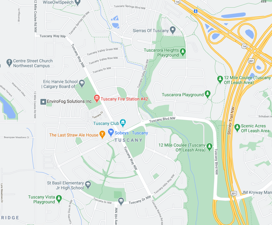
If you love walking in circles Tuscany is your place. Tuscany in Calgary, Alberta, not the one in Italy.
Grid Is Boring
Some have argued the grid system is boring. I don’t believe so. You can easily make a grid neighbourhood interesting with pocket parks, playgrounds and front yard landscaping. Infill housing also makes grid neighbourhoods interesting with the contrast between the old and new architecture. Straight streets also allow for pastoral, tree canopies that help make them park-like. The predominance of front porches vs front garages also makes grid neighbourhoods more welcoming than curved ones.
Link: Mid-Century Urban Ornamentation Fun
Last Word
To me there is no contest, grid neighbourhoods trump curved ones every time.
If you like this blog, you will like these links:
Hey Calgary: 24 new or improved main streets coming soon!