Southern Alberta Unique Photography Adventures
While Alberta is only the fourth largest province in Canada, it is twice the size of Norway and 1.5 times larger than Sweden. It has a diverse topography, from desert to grasslands, to alpine mountain terrain. It is therefore not surprising there are lots of remarkable off-the-beaten-path places for photographers to visit.
Due to ever changing weather conditions, nature photography is a bit like online gambling as you never know when you are going to hit the jackpot, but it is always fun. If you are really into casinos, Century Down’s Casino and Racetrack, just north of Calgary off QE2 highway is a good option especially for those interested in trying their hand at horse racing photography. And if you don’t know how to bet on horse races, they’ve got you covered. Attend a free “Betting Basics: What are the Odds?!” course every Saturday, Sunday and holidays, and receive a complimentary race day program and a $2 betting voucher.

Here are just a few unique southern Alberta photo spots:
Head-Smash-In-Buffalo Jump
In south-west Alberta (just 20 minutes west of Fort Macleod, off highway #785), the remains of marked trails and an aboriginal camp, and vast quantities of buffalo (American Bison) skeletons can still be found. Using their excellent knowledge of the topography and of buffalo behaviour, the indigenous people killed their prey by chasing them over a precipice; the carcasses were later carved up in the camp below.
For 6,000+ years, the bison provided the Aboriginal peoples of North America's Great Plains with many of life's requirements - meat for food, hides for clothing and shelter, sinew, bone and horn for tools, and dung for fires. The principal means of killing large numbers of bison was the buffalo jump, where herds were stampeded over cliffs and butchered at the bottom. Buffalo jumps were common on the northern Plains. But the biggest, oldest and best-preserved buffalo jump in North America is the Head-Smashed-In (or estipah-skikikini-kots in Blackfoot) Buffalo Jump in the Porcupine Hills of southwestern Alberta.

Red Rock Coulee
Not at lot of people visit Red Rock Coulee located south of the town of Seven Persons just off highway #887. There is no interpretive centre, no facilities, just a strange landscape with dozens of roundish sandstone rocks up to 2.5 meters in diameter. They were formed in prehistoric seas out of materials like shells and plants, and then grew by collecting sand, sediments and minerals from the surrounding area. You can see the growth layers on some of the broken boulders. FYI: Be on the lookout for rattlesnakes.

Writing-On-Stone Provincial Park
This park is home to a vast collection of hoodoos that you can wander all day and always see something different. You can take a guided tour of the hoodoos and see some of the indigenous petroglyphs – it is a walk back in time. The Park is known for having the highest concentration of indigenous rock art in North America with its 50+ petroglyph sites and thousands of works. We took one of the guided tours which was not only very informative, but very useful too as the rock paintings and petroglyphs are easy to miss. (FYI: Technically, rock carvings are called petroglyphs and rock paintings pictographs.)
Divided into two sections, the Park has one that is open to the public and one that is closed as it has several active archeological digs. Our tour guide took us in a van into the archeological side which allowed us to get up close to three sites with indigenous artworks.
The Park is located along the Milk River, about 30 minutes east of the town of Milk River.
FYI: The Milk River is named for its characteristic milky, or cloudy, appearance, which comes from the white silt carried by the water from the badlands and Rocky Mountains. American explorers Meriwether Lewis and William Clark gave the river its name in 1805, comparing its color to "a cup of tea with the admixture of a tablespoon full of milk".


Horseshoe Canyon
Horseshoe Canyon is a well-known Canadian Badlands destination in Alberta, Canada, located just west of Drumheller, featuring a striking U-shaped valley with striped rock formations that are ~70 million years old. Visitors can hike trails down to the canyon floor to get a closer look at the landscape or enjoy scenic views from rim-level platforms. It is even possible to organize a helicopter tour of the canyon. It is located just off highway #9, fifteen minutes east of Drumheller.
Fifteen minutes southeast of Drumheller is the Willow Creek Hoodoo Trail, just off Highway #10.

East Coulee and Atlas Coal Mine
The streets of East Coulee are lined with huge trees, giving it an oasis-like feeling compared to the barren surrounding landscape. The tiny miners’ homes are a reminder of how early pioneers lived in modest small homes, each probably housed six or more people.
Nothing is left of its main street except one large building that has been converted into a studio for the manufacturing of dinosaur-related items for museums, movie studios, parades and theme parks. There is also a small gift shop with a lovely garden.
Just across the river from East Coulee is The Atlas Coal Mine National Historic Site that operated from 1936 to 1979. It is the most complete historic coal mine in Canada and is home to the country's last standing wooden coal tipple. In fact, it’s the largest still standing in North America. Designated a Provincial Historic Resource in 1989, it achieved National Historic Site of Canada status in 2002.
Various guided tour options exist. You can take a train ride through the site, walk up the tipple or tour the 210 foot underground conveyor tunnel. The facilities are open to visitors from May to Thanksgiving weekend.
With not enough time to do a tour (we arrived 20 minutes before closing) we instead walked up the dead end road west of the parking lot where we had heard there was an art installation. Sure enough, at the end of the road, stood dozens of five foot tall tree limbs with alien head-like nobs stuck in the ground with rock piles at their base to help them stay standing. Many of the limbs had various small trinkets hanging or sitting on them, creating a somber, graveyard sense of place. There are no markings or signs indicating who did them, why there are there, which only adds to the mystique.


Lake Abraham
The lake is the Alberta’s largest reservoir, created by the construction of the Bighorn Dam on the North Saskatchewan River. It has a spectacular blue colour that is characteristic of glacial lakes in the Rockies, due to the silt of the eroding mountain rocks. In the winder Trapped methane causes frozen bubbles to form under the ice on the lake's surface. This phenomenon results when decaying plants on the lakebed release methane gas, which creates bubbles that become trapped within the ice, in suspended animation, just below the surface as the lake begins to freeze. The visual effects formed by the resulting stacks of bubbles, frozen while rising toward the surface, combined with the clear blue water, have made Abraham Lake a popular destination for photographers and nature observers. The ice coverage of the lakes varies throughout the winter. Abraham Lake is usually frozen by late December. Ideal viewing of the ice bubble season is from mid-January to mid-February. It is located off Highway #11 about 2 hours from Banff or Red Deer.

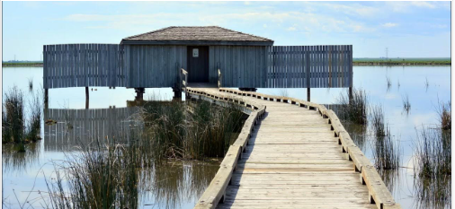
Frank Lake
Frank Lake, found 50 km southeast of Calgary near High River, Alberta, is a productive wetland important to hundreds of bird species. Once completely dry, this wetland has been saved through a progressive partnership between industry, government and Ducks Unlimited that began in 1952. It is now listed as one most important bird areas in Canada.
Today the wetland complex now encompasses three basins totaling nearly 3,100 acres of flooded area with an additional 1,700 acres of managed upland habitat. The uplands consist of both native and seeded grasslands that benefit wildlife and waterfowl nesting. To date,194 bird species have been recorded at the lake, including tundra and trumpeter swans. In 2020, the endangered whooping cranes were spotted near Frank Lake.